You are here: Home > Network List > LD - Lamont-Doherty Cooperative Seismographic Network Stations List
> Station WUPA West Chester University of Pennsylvania > Earthquake Result Viewer
WUPA West Chester University of Pennsylvania - Earthquake Result Viewer
| Earthquake location: |
Northern Alaska |
| Earthquake latitude/longitude: |
69.5/-144.4 |
| Earthquake time(UTC): |
2018/08/12 (224) 21:15:01 GMT |
| Earthquake Depth: |
1.7 km |
| Earthquake Magnitude: |
6.0 Mww |
| Earthquake Catalog/Contributor: |
NEIC PDE/ak |
|
| Network: |
LD Lamont-Doherty Cooperative Seismographic Network |
| Station: |
WUPA West Chester University of Pennsylvania |
| Lat/Lon: |
39.93 N/75.61 W |
| Elevation: |
86 m |
|
| Distance: |
45.9 deg |
| Az: |
92.859 deg |
| Baz: |
332.798 deg |
| Ray Param: |
0.07102786 |
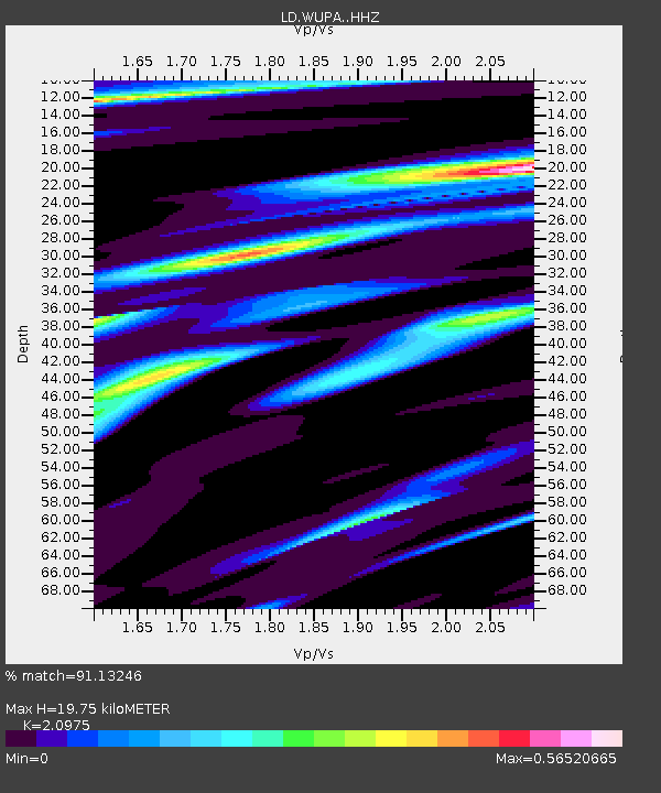
| Estimated Moho Depth: |
19.75 km |
| Estimated Crust Vp/Vs: |
2.10 |
| Assumed Crust Vp: |
6.287 km/s |
| Estimated Crust Vs: |
2.998 km/s |
| Estimated Crust Poisson's Ratio: |
0.35 |
|
| Radial Match: |
91.13246 % |
| Radial Bump: |
259 |
| Transverse Match: |
71.2027 % |
| Transverse Bump: |
356 |
| SOD ConfigId: |
13570011 |
| Insert Time: |
2019-04-30 19:17:23.671 +0000 |
| GWidth: |
2.5 |
| Max Bumps: |
400 |
| Tol: |
0.001 |
|

Signal To Noise
| Channel | StoN | STA | LTA |
| LD:WUPA: :HHZ:20180812T21:22:54.455014Z | 20.928505 | 7.7211405E-7 | 3.689294E-8 |
| LD:WUPA: :HHN:20180812T21:22:54.455014Z | 7.527839 | 2.7327906E-7 | 3.6302456E-8 |
| LD:WUPA: :HHE:20180812T21:22:54.455014Z | 4.214671 | 1.298432E-7 | 3.0807435E-8 |
| Arrivals |
| Ps | 3.6 SECOND |
| PpPs | 9.2 SECOND |
| PsPs/PpSs | 13 SECOND |


