You are here: Home > Network List > MU - Miami University Seismic Network Stations List
> Station MUB2 Belmont > Earthquake Result Viewer
MUB2 Belmont - Earthquake Result Viewer
| Earthquake location: |
Northern Alaska |
| Earthquake latitude/longitude: |
69.5/-144.4 |
| Earthquake time(UTC): |
2018/08/12 (224) 21:15:01 GMT |
| Earthquake Depth: |
1.7 km |
| Earthquake Magnitude: |
6.0 Mww |
| Earthquake Catalog/Contributor: |
NEIC PDE/ak |
|
| Network: |
MU Miami University Seismic Network |
| Station: |
MUB2 Belmont |
| Lat/Lon: |
40.08 N/80.90 W |
| Elevation: |
384 m |
|
| Distance: |
43.9 deg |
| Az: |
97.893 deg |
| Baz: |
332.976 deg |
| Ray Param: |
0.07229762 |
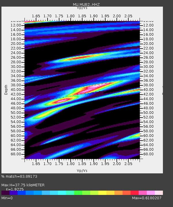
| Estimated Moho Depth: |
37.75 km |
| Estimated Crust Vp/Vs: |
1.92 |
| Assumed Crust Vp: |
6.483 km/s |
| Estimated Crust Vs: |
3.372 km/s |
| Estimated Crust Poisson's Ratio: |
0.31 |
|
| Radial Match: |
83.89173 % |
| Radial Bump: |
364 |
| Transverse Match: |
70.18784 % |
| Transverse Bump: |
400 |
| SOD ConfigId: |
13570011 |
| Insert Time: |
2019-04-30 19:17:57.641 +0000 |
| GWidth: |
2.5 |
| Max Bumps: |
400 |
| Tol: |
0.001 |
|

Signal To Noise
| Channel | StoN | STA | LTA |
| MU:MUB2: :HHZ:20180812T21:22:38.630001Z | 10.475126 | 4.6746877E-6 | 4.462655E-7 |
| MU:MUB2: :HHN:20180812T21:22:38.630001Z | 5.404527 | 2.1178146E-6 | 3.9185937E-7 |
| MU:MUB2: :HHE:20180812T21:22:38.630001Z | 2.6493652 | 8.5142904E-7 | 3.2137095E-7 |
| Arrivals |
| Ps | 5.7 SECOND |
| PpPs | 16 SECOND |
| PsPs/PpSs | 22 SECOND |


