You are here: Home > Network List > MU - Miami University Seismic Network Stations List
> Station MUM1 Monroe > Earthquake Result Viewer
MUM1 Monroe - Earthquake Result Viewer
| Earthquake location: |
Northern Alaska |
| Earthquake latitude/longitude: |
69.5/-144.4 |
| Earthquake time(UTC): |
2018/08/12 (224) 21:15:01 GMT |
| Earthquake Depth: |
1.7 km |
| Earthquake Magnitude: |
6.0 Mww |
| Earthquake Catalog/Contributor: |
NEIC PDE/ak |
|
| Network: |
MU Miami University Seismic Network |
| Station: |
MUM1 Monroe |
| Lat/Lon: |
39.65 N/81.15 W |
| Elevation: |
310 m |
|
| Distance: |
44.2 deg |
| Az: |
98.427 deg |
| Baz: |
333.198 deg |
| Ray Param: |
0.07210628 |
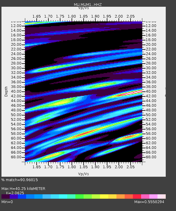
| Estimated Moho Depth: |
40.25 km |
| Estimated Crust Vp/Vs: |
2.06 |
| Assumed Crust Vp: |
6.207 km/s |
| Estimated Crust Vs: |
3.009 km/s |
| Estimated Crust Poisson's Ratio: |
0.35 |
|
| Radial Match: |
90.96815 % |
| Radial Bump: |
400 |
| Transverse Match: |
57.67498 % |
| Transverse Bump: |
400 |
| SOD ConfigId: |
13570011 |
| Insert Time: |
2019-04-30 19:17:58.193 +0000 |
| GWidth: |
2.5 |
| Max Bumps: |
400 |
| Tol: |
0.001 |
|

Signal To Noise
| Channel | StoN | STA | LTA |
| MU:MUM1: :HHZ:20180812T21:22:41.040005Z | 13.957305 | 5.261759E-6 | 3.769896E-7 |
| MU:MUM1: :HHN:20180812T21:22:41.040005Z | 5.248711 | 2.4751344E-6 | 4.715699E-7 |
| MU:MUM1: :HHE:20180812T21:22:41.040005Z | 4.284791 | 1.4891698E-6 | 3.475478E-7 |
| Arrivals |
| Ps | 7.3 SECOND |
| PpPs | 19 SECOND |
| PsPs/PpSs | 26 SECOND |


