You are here: Home > Network List > MU - Miami University Seismic Network Stations List
> Station MUH1 Harrison > Earthquake Result Viewer
MUH1 Harrison - Earthquake Result Viewer
| Earthquake location: |
Northern Alaska |
| Earthquake latitude/longitude: |
69.5/-144.4 |
| Earthquake time(UTC): |
2018/08/12 (224) 21:15:01 GMT |
| Earthquake Depth: |
1.7 km |
| Earthquake Magnitude: |
6.0 Mww |
| Earthquake Catalog/Contributor: |
NEIC PDE/ak |
|
| Network: |
MU Miami University Seismic Network |
| Station: |
MUH1 Harrison |
| Lat/Lon: |
40.23 N/81.15 W |
| Elevation: |
365 m |
|
| Distance: |
43.6 deg |
| Az: |
98.041 deg |
| Baz: |
332.925 deg |
| Ray Param: |
0.07243797 |
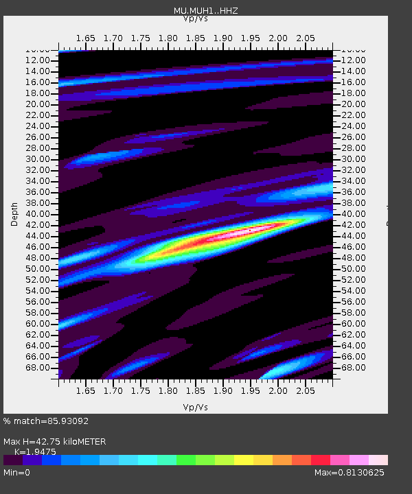
| Estimated Moho Depth: |
42.75 km |
| Estimated Crust Vp/Vs: |
1.95 |
| Assumed Crust Vp: |
6.483 km/s |
| Estimated Crust Vs: |
3.329 km/s |
| Estimated Crust Poisson's Ratio: |
0.32 |
|
| Radial Match: |
85.93092 % |
| Radial Bump: |
346 |
| Transverse Match: |
72.87159 % |
| Transverse Bump: |
387 |
| SOD ConfigId: |
13570011 |
| Insert Time: |
2019-04-30 19:17:58.307 +0000 |
| GWidth: |
2.5 |
| Max Bumps: |
400 |
| Tol: |
0.001 |
|

Signal To Noise
| Channel | StoN | STA | LTA |
| MU:MUH1: :HHZ:20180812T21:22:36.904995Z | 8.830458 | 4.8636475E-6 | 5.5078095E-7 |
| MU:MUH1: :HHN:20180812T21:22:36.904995Z | 5.279134 | 2.1926019E-6 | 4.1533366E-7 |
| MU:MUH1: :HHE:20180812T21:22:36.904995Z | 2.5475652 | 6.828916E-7 | 2.680566E-7 |
| Arrivals |
| Ps | 6.6 SECOND |
| PpPs | 18 SECOND |
| PsPs/PpSs | 25 SECOND |


