You are here: Home > Network List > N4 - Central and EAstern US Network Stations List
> Station E38A The Farm, Brule, WI, USA > Earthquake Result Viewer
E38A The Farm, Brule, WI, USA - Earthquake Result Viewer
| Earthquake location: |
Northern Alaska |
| Earthquake latitude/longitude: |
69.5/-144.4 |
| Earthquake time(UTC): |
2018/08/12 (224) 21:15:01 GMT |
| Earthquake Depth: |
1.7 km |
| Earthquake Magnitude: |
6.0 Mww |
| Earthquake Catalog/Contributor: |
NEIC PDE/ak |
|
| Network: |
N4 Central and EAstern US Network |
| Station: |
E38A The Farm, Brule, WI, USA |
| Lat/Lon: |
46.61 N/91.55 W |
| Elevation: |
341 m |
|
| Distance: |
34.4 deg |
| Az: |
103.829 deg |
| Baz: |
330.286 deg |
| Ray Param: |
0.077757984 |
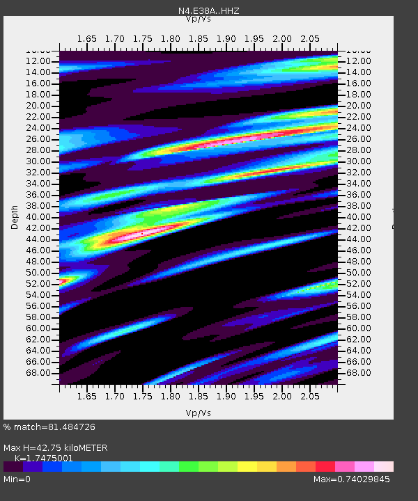
| Estimated Moho Depth: |
42.75 km |
| Estimated Crust Vp/Vs: |
1.75 |
| Assumed Crust Vp: |
6.467 km/s |
| Estimated Crust Vs: |
3.701 km/s |
| Estimated Crust Poisson's Ratio: |
0.26 |
|
| Radial Match: |
81.484726 % |
| Radial Bump: |
396 |
| Transverse Match: |
77.08213 % |
| Transverse Bump: |
400 |
| SOD ConfigId: |
13570011 |
| Insert Time: |
2019-04-30 19:18:18.682 +0000 |
| GWidth: |
2.5 |
| Max Bumps: |
400 |
| Tol: |
0.001 |
|

Signal To Noise
| Channel | StoN | STA | LTA |
| N4:E38A: :HHZ:20180812T21:21:20.019986Z | 12.485914 | 1.6079701E-6 | 1.2878273E-7 |
| N4:E38A: :HHN:20180812T21:21:20.019986Z | 6.782262 | 8.298039E-7 | 1.2234914E-7 |
| N4:E38A: :HHE:20180812T21:21:20.019986Z | 4.351018 | 3.8785538E-7 | 8.9141295E-8 |
| Arrivals |
| Ps | 5.3 SECOND |
| PpPs | 17 SECOND |
| PsPs/PpSs | 22 SECOND |


