You are here: Home > Network List > N4 - Central and EAstern US Network Stations List
> Station I45A Fountain, MI, USA > Earthquake Result Viewer
I45A Fountain, MI, USA - Earthquake Result Viewer
| Earthquake location: |
Northern Alaska |
| Earthquake latitude/longitude: |
69.5/-144.4 |
| Earthquake time(UTC): |
2018/08/12 (224) 21:15:01 GMT |
| Earthquake Depth: |
1.7 km |
| Earthquake Magnitude: |
6.0 Mww |
| Earthquake Catalog/Contributor: |
NEIC PDE/ak |
|
| Network: |
N4 Central and EAstern US Network |
| Station: |
I45A Fountain, MI, USA |
| Lat/Lon: |
44.04 N/86.23 W |
| Elevation: |
215 m |
|
| Distance: |
38.5 deg |
| Az: |
100.426 deg |
| Baz: |
331.32 deg |
| Ray Param: |
0.07553689 |
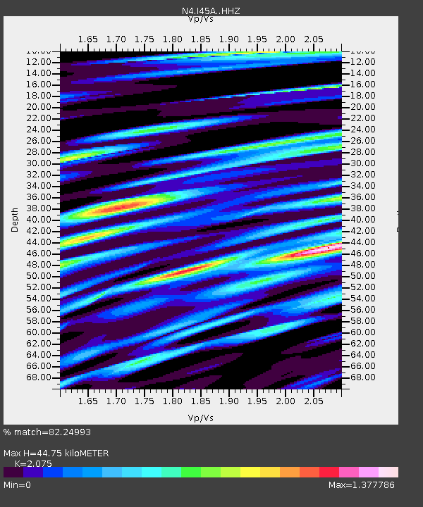
| Estimated Moho Depth: |
44.75 km |
| Estimated Crust Vp/Vs: |
2.08 |
| Assumed Crust Vp: |
6.53 km/s |
| Estimated Crust Vs: |
3.147 km/s |
| Estimated Crust Poisson's Ratio: |
0.35 |
|
| Radial Match: |
82.24993 % |
| Radial Bump: |
400 |
| Transverse Match: |
56.499092 % |
| Transverse Bump: |
400 |
| SOD ConfigId: |
13570011 |
| Insert Time: |
2019-04-30 19:18:30.017 +0000 |
| GWidth: |
2.5 |
| Max Bumps: |
400 |
| Tol: |
0.001 |
|

Signal To Noise
| Channel | StoN | STA | LTA |
| N4:I45A: :HHZ:20180812T21:21:54.719998Z | 10.525471 | 1.7809307E-6 | 1.69202E-7 |
| N4:I45A: :HHN:20180812T21:21:54.719998Z | 5.3890176 | 1.2751428E-6 | 2.3661882E-7 |
| N4:I45A: :HHE:20180812T21:21:54.719998Z | 2.5806909 | 7.1405435E-7 | 2.7669114E-7 |
| Arrivals |
| Ps | 7.9 SECOND |
| PpPs | 20 SECOND |
| PsPs/PpSs | 28 SECOND |


