You are here: Home > Network List > N4 - Central and EAstern US Network Stations List
> Station T57A Hurt, VA, USA > Earthquake Result Viewer
T57A Hurt, VA, USA - Earthquake Result Viewer
| Earthquake location: |
Northern Alaska |
| Earthquake latitude/longitude: |
69.5/-144.4 |
| Earthquake time(UTC): |
2018/08/12 (224) 21:15:01 GMT |
| Earthquake Depth: |
1.7 km |
| Earthquake Magnitude: |
6.0 Mww |
| Earthquake Catalog/Contributor: |
NEIC PDE/ak |
|
| Network: |
N4 Central and EAstern US Network |
| Station: |
T57A Hurt, VA, USA |
| Lat/Lon: |
37.00 N/79.25 W |
| Elevation: |
230 m |
|
| Distance: |
47.2 deg |
| Az: |
98.192 deg |
| Baz: |
334.207 deg |
| Ray Param: |
0.070172496 |
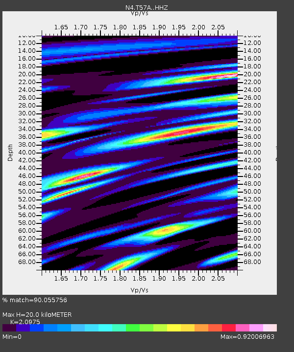
| Estimated Moho Depth: |
20.0 km |
| Estimated Crust Vp/Vs: |
2.10 |
| Assumed Crust Vp: |
6.419 km/s |
| Estimated Crust Vs: |
3.06 km/s |
| Estimated Crust Poisson's Ratio: |
0.35 |
|
| Radial Match: |
90.055756 % |
| Radial Bump: |
326 |
| Transverse Match: |
68.80849 % |
| Transverse Bump: |
400 |
| SOD ConfigId: |
13570011 |
| Insert Time: |
2019-04-30 19:19:26.811 +0000 |
| GWidth: |
2.5 |
| Max Bumps: |
400 |
| Tol: |
0.001 |
|

Signal To Noise
| Channel | StoN | STA | LTA |
| N4:T57A: :HHZ:20180812T21:23:04.989987Z | 12.931514 | 8.415553E-7 | 6.507786E-8 |
| N4:T57A: :HHN:20180812T21:23:04.989987Z | 9.838859 | 3.3392388E-7 | 3.393929E-8 |
| N4:T57A: :HHE:20180812T21:23:04.989987Z | 4.3347683 | 2.0434113E-7 | 4.7140034E-8 |
| Arrivals |
| Ps | 3.6 SECOND |
| PpPs | 9.2 SECOND |
| PsPs/PpSs | 13 SECOND |


