You are here: Home > Network List > CI - Caltech Regional Seismic Network Stations List
> Station PHL Parkhill, California, USA > Earthquake Result Viewer
PHL Parkhill, California, USA - Earthquake Result Viewer
| Earthquake location: |
Kermadec Islands Region |
| Earthquake latitude/longitude: |
-28.0/-176.8 |
| Earthquake time(UTC): |
1999/12/25 (359) 18:38:50 GMT |
| Earthquake Depth: |
33 km |
| Earthquake Magnitude: |
5.8 MB, 5.6 MS, 5.8 MW, 5.1 MW |
| Earthquake Catalog/Contributor: |
WHDF/NEIC |
|
| Network: |
CI Caltech Regional Seismic Network |
| Station: |
PHL Parkhill, California, USA |
| Lat/Lon: |
35.41 N/120.55 W |
| Elevation: |
351 m |
|
| Distance: |
82.4 deg |
| Az: |
43.25 deg |
| Baz: |
227.88 deg |
| Ray Param: |
0.046861786 |
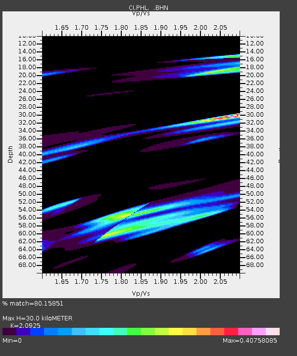
| Estimated Moho Depth: |
30.0 km |
| Estimated Crust Vp/Vs: |
2.09 |
| Assumed Crust Vp: |
6.183 km/s |
| Estimated Crust Vs: |
2.955 km/s |
| Estimated Crust Poisson's Ratio: |
0.35 |
|
| Radial Match: |
80.15851 % |
| Radial Bump: |
400 |
| Transverse Match: |
55.613457 % |
| Transverse Bump: |
400 |
| SOD ConfigId: |
3770 |
| Insert Time: |
2010-02-26 02:11:29.995 +0000 |
| GWidth: |
2.5 |
| Max Bumps: |
400 |
| Tol: |
0.001 |
|

Signal To Noise
| Channel | StoN | STA | LTA |
| CI:PHL: :BHN:19991225T18:50:38.272007Z | 0.9562517 | 3.134302E-7 | 3.2776958E-7 |
| CI:PHL: :BHE:19991225T18:50:38.272007Z | 1.156089 | 4.2457336E-7 | 3.6724973E-7 |
| CI:PHL: :BHZ:19991225T18:50:38.272007Z | 1.624398 | 4.678484E-7 | 2.880134E-7 |
| Arrivals |
| Ps | 5.4 SECOND |
| PpPs | 15 SECOND |
| PsPs/PpSs | 20 SECOND |


