You are here: Home > Network List > NN - Western Great Basin/Eastern Sierra Nevada Stations List
> Station PAH Pah Rah Range, Nevada w84gm > Earthquake Result Viewer
PAH Pah Rah Range, Nevada w84gm - Earthquake Result Viewer
| Earthquake location: |
Northern Alaska |
| Earthquake latitude/longitude: |
69.5/-144.4 |
| Earthquake time(UTC): |
2018/08/12 (224) 21:15:01 GMT |
| Earthquake Depth: |
1.7 km |
| Earthquake Magnitude: |
6.0 Mww |
| Earthquake Catalog/Contributor: |
NEIC PDE/ak |
|
| Network: |
NN Western Great Basin/Eastern Sierra Nevada |
| Station: |
PAH Pah Rah Range, Nevada w84gm |
| Lat/Lon: |
39.71 N/119.39 W |
| Elevation: |
1520 m |
|
| Distance: |
32.7 deg |
| Az: |
142.894 deg |
| Baz: |
344.023 deg |
| Ray Param: |
0.07856744 |
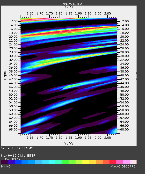
| Estimated Moho Depth: |
10.0 km |
| Estimated Crust Vp/Vs: |
1.84 |
| Assumed Crust Vp: |
6.279 km/s |
| Estimated Crust Vs: |
3.417 km/s |
| Estimated Crust Poisson's Ratio: |
0.29 |
|
| Radial Match: |
89.014145 % |
| Radial Bump: |
280 |
| Transverse Match: |
69.86427 % |
| Transverse Bump: |
297 |
| SOD ConfigId: |
13570011 |
| Insert Time: |
2019-04-30 19:20:07.420 +0000 |
| GWidth: |
2.5 |
| Max Bumps: |
400 |
| Tol: |
0.001 |
|

Signal To Noise
| Channel | StoN | STA | LTA |
| NN:PAH: :HHZ:20180812T21:21:04.64999Z | 2.1691113 | 2.987264E-7 | 1.3771835E-7 |
| NN:PAH: :HHN:20180812T21:21:04.64999Z | 1.6798211 | 1.3994871E-7 | 8.3311676E-8 |
| NN:PAH: :HHE:20180812T21:21:04.64999Z | 1.449129 | 1.7639141E-7 | 1.2172238E-7 |
| Arrivals |
| Ps | 1.4 SECOND |
| PpPs | 4.2 SECOND |
| PsPs/PpSs | 5.6 SECOND |


