You are here: Home > Network List > CI - Caltech Regional Seismic Network Stations List
> Station PHL Parkhill, California, USA > Earthquake Result Viewer
PHL Parkhill, California, USA - Earthquake Result Viewer

| Earthquake location: |
Caribbean Sea |
| Earthquake latitude/longitude: |
17.6/-82.4 |
| Earthquake time(UTC): |
1999/12/01 (335) 19:23:06 GMT |
| Earthquake Depth: |
10 km |
| Earthquake Magnitude: |
5.8 MB, 5.8 MS, 6.3 MW, 6.3 MW |
| Earthquake Catalog/Contributor: |
WHDF/NEIC |
|
| Network: |
CI Caltech Regional Seismic Network |
| Station: |
PHL Parkhill, California, USA |
| Lat/Lon: |
35.41 N/120.55 W |
| Elevation: |
351 m |
|
| Distance: |
38.2 deg |
| Az: |
305.222 deg |
| Baz: |
107.525 deg |
| Ray Param: |
0.07570705 |
| Estimated Moho Depth: |
23.5 km |
| Estimated Crust Vp/Vs: |
1.76 |
| Assumed Crust Vp: |
6.183 km/s |
| Estimated Crust Vs: |
3.508 km/s |
| Estimated Crust Poisson's Ratio: |
0.26 |
|
| Radial Match: |
80.5462 % |
| Radial Bump: |
333 |
| Transverse Match: |
61.294495 % |
| Transverse Bump: |
400 |
| SOD ConfigId: |
3770 |
| Insert Time: |
2010-02-26 02:11:31.125 +0000 |
| GWidth: |
2.5 |
| Max Bumps: |
400 |
| Tol: |
0.001 |
|
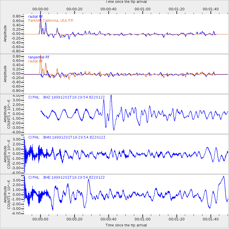
Signal To Noise
| Channel | StoN | STA | LTA |
| CI:PHL: :BHN:19991201T19:29:54.822012Z | 0.9023357 | 6.449635E-7 | 7.1477115E-7 |
| CI:PHL: :BHE:19991201T19:29:54.822012Z | 0.9432383 | 6.5299133E-7 | 6.922867E-7 |
| CI:PHL: :BHZ:19991201T19:29:54.822012Z | 1.034501 | 6.995573E-7 | 6.7622676E-7 |
| Arrivals |
| Ps | 3.1 SECOND |
| PpPs | 9.8 SECOND |
| PsPs/PpSs | 13 SECOND |


