You are here: Home > Network List > PE - Penn State Network Stations List
> Station PACH Chapman State Park, Clarendon, PA > Earthquake Result Viewer
PACH Chapman State Park, Clarendon, PA - Earthquake Result Viewer
| Earthquake location: |
Northern Alaska |
| Earthquake latitude/longitude: |
69.5/-144.4 |
| Earthquake time(UTC): |
2018/08/12 (224) 21:15:01 GMT |
| Earthquake Depth: |
1.7 km |
| Earthquake Magnitude: |
6.0 Mww |
| Earthquake Catalog/Contributor: |
NEIC PDE/ak |
|
| Network: |
PE Penn State Network |
| Station: |
PACH Chapman State Park, Clarendon, PA |
| Lat/Lon: |
41.76 N/79.17 W |
| Elevation: |
431 m |
|
| Distance: |
43.0 deg |
| Az: |
95.08 deg |
| Baz: |
332.061 deg |
| Ray Param: |
0.07286337 |
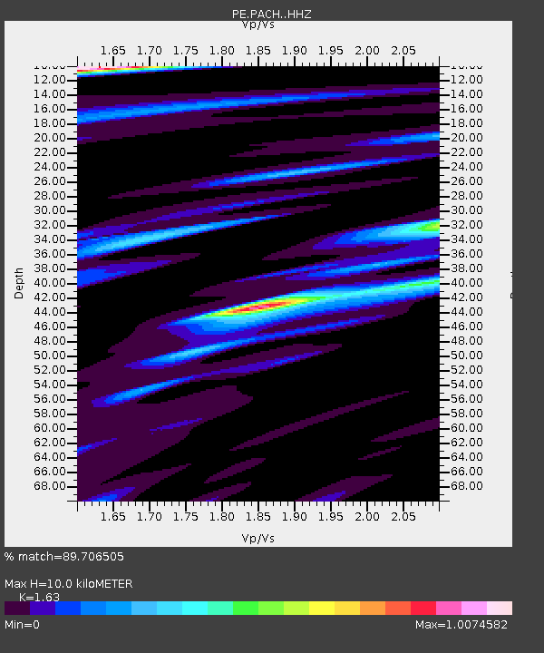
| Estimated Moho Depth: |
10.0 km |
| Estimated Crust Vp/Vs: |
1.63 |
| Assumed Crust Vp: |
6.121 km/s |
| Estimated Crust Vs: |
3.755 km/s |
| Estimated Crust Poisson's Ratio: |
0.20 |
|
| Radial Match: |
89.706505 % |
| Radial Bump: |
332 |
| Transverse Match: |
69.88309 % |
| Transverse Bump: |
400 |
| SOD ConfigId: |
13570011 |
| Insert Time: |
2019-04-30 19:21:01.735 +0000 |
| GWidth: |
2.5 |
| Max Bumps: |
400 |
| Tol: |
0.001 |
|

Signal To Noise
| Channel | StoN | STA | LTA |
| PE:PACH: :HHZ:20180812T21:22:31.554989Z | 17.811304 | 2.197902E-6 | 1.2339926E-7 |
| PE:PACH: :HHN:20180812T21:22:31.554989Z | 9.459222 | 8.803542E-7 | 9.306836E-8 |
| PE:PACH: :HHE:20180812T21:22:31.554989Z | 4.804274 | 4.1763948E-7 | 8.693082E-8 |
| Arrivals |
| Ps | 1.1 SECOND |
| PpPs | 4.0 SECOND |
| PsPs/PpSs | 5.1 SECOND |


