You are here: Home > Network List > PE - Penn State Network Stations List
> Station PACW Cowans Gap State Park, Fort Loudon, PA > Earthquake Result Viewer
PACW Cowans Gap State Park, Fort Loudon, PA - Earthquake Result Viewer
| Earthquake location: |
Northern Alaska |
| Earthquake latitude/longitude: |
69.5/-144.4 |
| Earthquake time(UTC): |
2018/08/12 (224) 21:15:01 GMT |
| Earthquake Depth: |
1.7 km |
| Earthquake Magnitude: |
6.0 Mww |
| Earthquake Catalog/Contributor: |
NEIC PDE/ak |
|
| Network: |
PE Penn State Network |
| Station: |
PACW Cowans Gap State Park, Fort Loudon, PA |
| Lat/Lon: |
40.00 N/77.92 W |
| Elevation: |
394 m |
|
| Distance: |
45.0 deg |
| Az: |
95.045 deg |
| Baz: |
332.848 deg |
| Ray Param: |
0.07160097 |
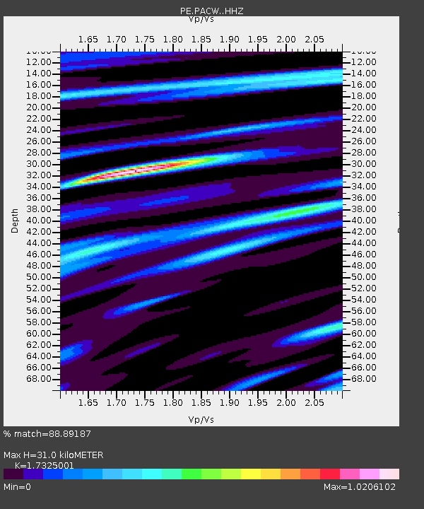
| Estimated Moho Depth: |
31.0 km |
| Estimated Crust Vp/Vs: |
1.73 |
| Assumed Crust Vp: |
6.419 km/s |
| Estimated Crust Vs: |
3.705 km/s |
| Estimated Crust Poisson's Ratio: |
0.25 |
|
| Radial Match: |
88.89187 % |
| Radial Bump: |
374 |
| Transverse Match: |
77.44098 % |
| Transverse Bump: |
400 |
| SOD ConfigId: |
13570011 |
| Insert Time: |
2019-04-30 19:21:01.892 +0000 |
| GWidth: |
2.5 |
| Max Bumps: |
400 |
| Tol: |
0.001 |
|

Signal To Noise
| Channel | StoN | STA | LTA |
| PE:PACW: :HHZ:20180812T21:22:47.570004Z | 25.43883 | 1.857621E-6 | 7.302305E-8 |
| PE:PACW: :HHN:20180812T21:22:47.570004Z | 14.826649 | 8.292695E-7 | 5.5931014E-8 |
| PE:PACW: :HHE:20180812T21:22:47.570004Z | 3.3779006 | 3.516999E-7 | 1.04117895E-7 |
| Arrivals |
| Ps | 3.8 SECOND |
| PpPs | 12 SECOND |
| PsPs/PpSs | 16 SECOND |


