You are here: Home > Network List > TA - USArray Transportable Network (new EarthScope stations) Stations List
> Station L44A Lake County Forest Preserve, Grayslake, IL, USA > Earthquake Result Viewer
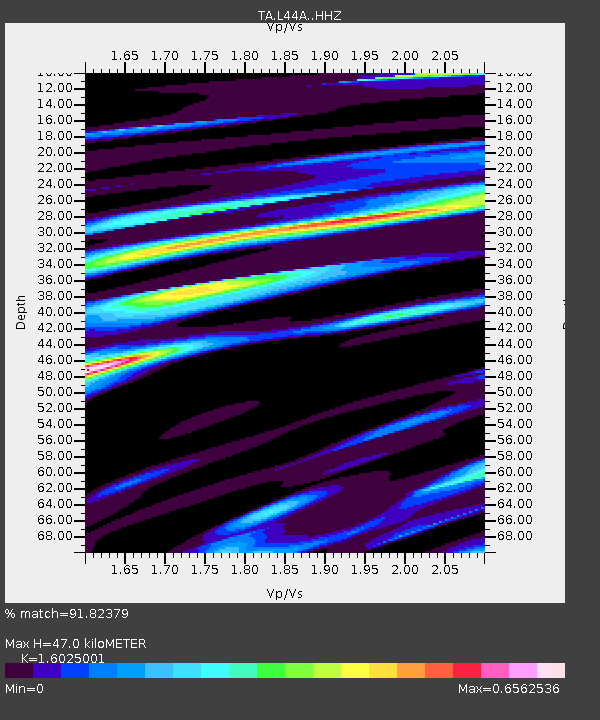
L44A Lake County Forest Preserve, Grayslake, IL, USA - Earthquake Result Viewer
| Earthquake location: |
Northern Alaska |
| Earthquake latitude/longitude: |
69.5/-144.4 |
| Earthquake time(UTC): |
2018/08/12 (224) 21:15:01 GMT |
| Earthquake Depth: |
1.7 km |
| Earthquake Magnitude: |
6.0 Mww |
| Earthquake Catalog/Contributor: |
NEIC PDE/ak |
|
| Network: |
TA USArray Transportable Network (new EarthScope stations) |
| Station: |
L44A Lake County Forest Preserve, Grayslake, IL, USA |
| Lat/Lon: |
42.18 N/87.91 W |
| Elevation: |
202 m |
|
| Distance: |
39.6 deg |
| Az: |
103.533 deg |
| Baz: |
332.591 deg |
| Ray Param: |
0.074923426 |
| Estimated Moho Depth: |
47.0 km |
| Estimated Crust Vp/Vs: |
1.60 |
| Assumed Crust Vp: |
6.483 km/s |
| Estimated Crust Vs: |
4.045 km/s |
| Estimated Crust Poisson's Ratio: |
0.18 |
|
| Radial Match: |
91.82379 % |
| Radial Bump: |
258 |
| Transverse Match: |
80.7209 % |
| Transverse Bump: |
400 |
| SOD ConfigId: |
13570011 |
| Insert Time: |
2019-04-30 19:22:02.771 +0000 |
| GWidth: |
2.5 |
| Max Bumps: |
400 |
| Tol: |
0.001 |
|

Signal To Noise
| Channel | StoN | STA | LTA |
| TA:L44A: :HHZ:20180812T21:22:03.600003Z | 21.039883 | 1.9575723E-6 | 9.3041024E-8 |
| TA:L44A: :HHN:20180812T21:22:03.600003Z | 9.445182 | 1.1910855E-6 | 1.2610509E-7 |
| TA:L44A: :HHE:20180812T21:22:03.600003Z | 5.955772 | 6.351734E-7 | 1.0664837E-7 |
| Arrivals |
| Ps | 4.7 SECOND |
| PpPs | 17 SECOND |
| PsPs/PpSs | 22 SECOND |


