You are here: Home > Network List > TA - USArray Transportable Network (new EarthScope stations) Stations List
> Station P49A Miami Univ. Ecology Research Center, OH, USA > Earthquake Result Viewer
P49A Miami Univ. Ecology Research Center, OH, USA - Earthquake Result Viewer
| Earthquake location: |
Northern Alaska |
| Earthquake latitude/longitude: |
69.5/-144.4 |
| Earthquake time(UTC): |
2018/08/12 (224) 21:15:01 GMT |
| Earthquake Depth: |
1.7 km |
| Earthquake Magnitude: |
6.0 Mww |
| Earthquake Catalog/Contributor: |
NEIC PDE/ak |
|
| Network: |
TA USArray Transportable Network (new EarthScope stations) |
| Station: |
P49A Miami Univ. Ecology Research Center, OH, USA |
| Lat/Lon: |
39.53 N/84.72 W |
| Elevation: |
272 m |
|
| Distance: |
43.0 deg |
| Az: |
102.07 deg |
| Baz: |
333.575 deg |
| Ray Param: |
0.07283459 |
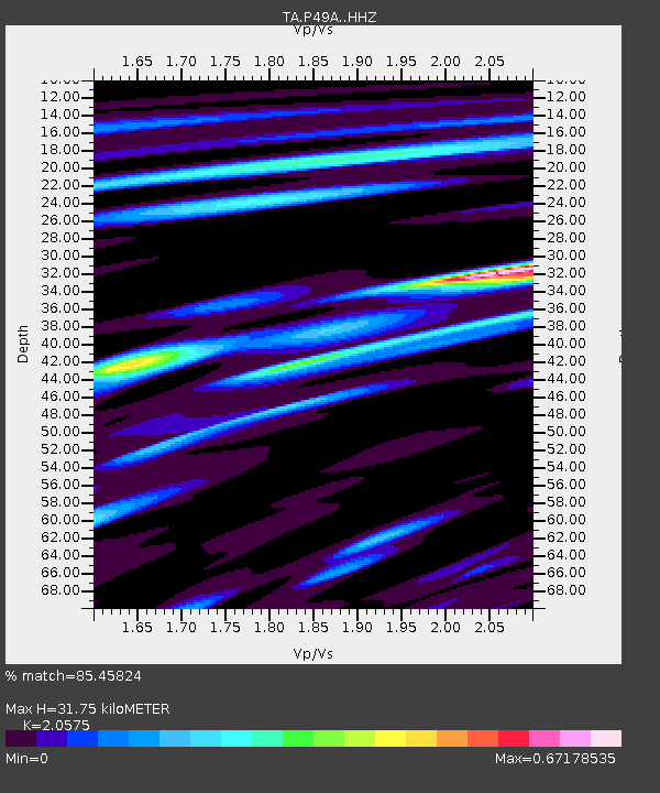
| Estimated Moho Depth: |
31.75 km |
| Estimated Crust Vp/Vs: |
2.06 |
| Assumed Crust Vp: |
6.498 km/s |
| Estimated Crust Vs: |
3.158 km/s |
| Estimated Crust Poisson's Ratio: |
0.35 |
|
| Radial Match: |
85.45824 % |
| Radial Bump: |
400 |
| Transverse Match: |
67.31432 % |
| Transverse Bump: |
400 |
| SOD ConfigId: |
13570011 |
| Insert Time: |
2019-04-30 19:22:09.566 +0000 |
| GWidth: |
2.5 |
| Max Bumps: |
400 |
| Tol: |
0.001 |
|

Signal To Noise
| Channel | StoN | STA | LTA |
| TA:P49A: :HHZ:20180812T21:22:31.92001Z | 17.393429 | 1.5315826E-6 | 8.805524E-8 |
| TA:P49A: :HHN:20180812T21:22:31.92001Z | 6.890824 | 7.322388E-7 | 1.0626288E-7 |
| TA:P49A: :HHE:20180812T21:22:31.92001Z | 4.5475283 | 4.165909E-7 | 9.160821E-8 |
| Arrivals |
| Ps | 5.5 SECOND |
| PpPs | 14 SECOND |
| PsPs/PpSs | 20 SECOND |


