You are here: Home > Network List > TA - USArray Transportable Network (new EarthScope stations) Stations List
> Station U21A Nageezi, NM, USA > Earthquake Result Viewer
U21A Nageezi, NM, USA - Earthquake Result Viewer

| Earthquake location: |
Costa Rica |
| Earthquake latitude/longitude: |
10.2/-84.2 |
| Earthquake time(UTC): |
2009/01/08 (008) 19:21:35 GMT |
| Earthquake Depth: |
14 km |
| Earthquake Magnitude: |
5.7 MB, 6.0 MS, 6.1 MW, 6.1 MW |
| Earthquake Catalog/Contributor: |
WHDF/NEIC |
|
| Network: |
TA USArray Transportable Network (new EarthScope stations) |
| Station: |
U21A Nageezi, NM, USA |
| Lat/Lon: |
36.43 N/107.66 W |
| Elevation: |
2124 m |
|
| Distance: |
33.7 deg |
| Az: |
324.632 deg |
| Baz: |
135.043 deg |
| Ray Param: |
0.07808244 |
| Estimated Moho Depth: |
13.0 km |
| Estimated Crust Vp/Vs: |
1.64 |
| Assumed Crust Vp: |
6.159 km/s |
| Estimated Crust Vs: |
3.761 km/s |
| Estimated Crust Poisson's Ratio: |
0.20 |
|
| Radial Match: |
89.764854 % |
| Radial Bump: |
316 |
| Transverse Match: |
37.832718 % |
| Transverse Bump: |
392 |
| SOD ConfigId: |
2834 |
| Insert Time: |
2010-03-06 13:51:24.065 +0000 |
| GWidth: |
2.5 |
| Max Bumps: |
400 |
| Tol: |
0.001 |
|
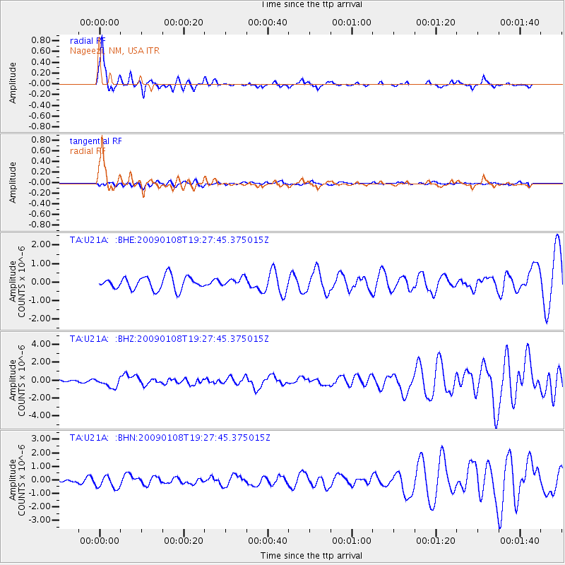
Signal To Noise
| Channel | StoN | STA | LTA |
| TA:U21A: :BHZ:20090108T19:27:45.375015Z | 2.6897297 | 5.366485E-7 | 1.9951761E-7 |
| TA:U21A: :BHN:20090108T19:27:45.375015Z | 1.6807398 | 4.5695424E-7 | 2.7187687E-7 |
| TA:U21A: :BHE:20090108T19:27:45.375015Z | 0.65504575 | 2.3046256E-7 | 3.5182666E-7 |
| Arrivals |
| Ps | 1.5 SECOND |
| PpPs | 5.2 SECOND |
| PsPs/PpSs | 6.6 SECOND |


