You are here: Home > Network List > AZ - ANZA Regional Network Stations List
> Station PFO AZ.PFO > Earthquake Result Viewer
PFO AZ.PFO - Earthquake Result Viewer
| Earthquake location: |
Andreanof Islands, Aleutian Is. |
| Earthquake latitude/longitude: |
51.4/-178.1 |
| Earthquake time(UTC): |
2018/08/15 (227) 21:56:54 GMT |
| Earthquake Depth: |
20 km |
| Earthquake Magnitude: |
6.6 Mww |
| Earthquake Catalog/Contributor: |
NEIC PDE/us |
|
| Network: |
AZ ANZA Regional Network |
| Station: |
PFO AZ.PFO |
| Lat/Lon: |
33.61 N/116.46 W |
| Elevation: |
1259 m |
|
| Distance: |
47.3 deg |
| Az: |
87.246 deg |
| Baz: |
311.477 deg |
| Ray Param: |
0.070056096 |
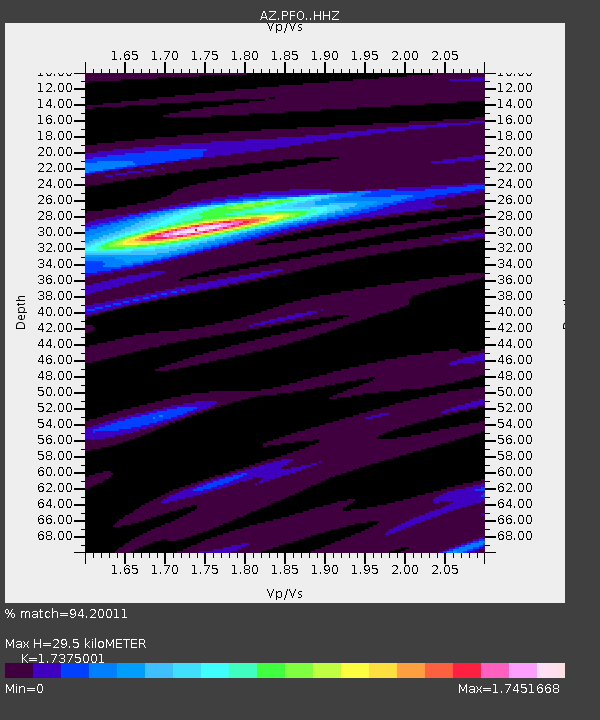
| Estimated Moho Depth: |
29.5 km |
| Estimated Crust Vp/Vs: |
1.74 |
| Assumed Crust Vp: |
6.264 km/s |
| Estimated Crust Vs: |
3.605 km/s |
| Estimated Crust Poisson's Ratio: |
0.25 |
|
| Radial Match: |
94.20011 % |
| Radial Bump: |
222 |
| Transverse Match: |
73.92385 % |
| Transverse Bump: |
400 |
| SOD ConfigId: |
13570011 |
| Insert Time: |
2019-04-30 19:28:22.154 +0000 |
| GWidth: |
2.5 |
| Max Bumps: |
400 |
| Tol: |
0.001 |
|

Signal To Noise
| Channel | StoN | STA | LTA |
| AZ:PFO: :HHZ:20180815T22:04:55.548005Z | 7.651069 | 9.948697E-7 | 1.3003016E-7 |
| AZ:PFO: :HHN:20180815T22:04:55.548005Z | 5.917267 | 4.443875E-7 | 7.510013E-8 |
| AZ:PFO: :HHE:20180815T22:04:55.548005Z | 2.1856337 | 2.5010596E-7 | 1.1443178E-7 |
| Arrivals |
| Ps | 3.7 SECOND |
| PpPs | 12 SECOND |
| PsPs/PpSs | 16 SECOND |


