You are here: Home > Network List > BE - Belgian Seismic Network Stations List
> Station MEM Membach, Belgium > Earthquake Result Viewer
MEM Membach, Belgium - Earthquake Result Viewer
| Earthquake location: |
Andreanof Islands, Aleutian Is. |
| Earthquake latitude/longitude: |
51.4/-178.1 |
| Earthquake time(UTC): |
2018/08/15 (227) 21:56:54 GMT |
| Earthquake Depth: |
20 km |
| Earthquake Magnitude: |
6.6 Mww |
| Earthquake Catalog/Contributor: |
NEIC PDE/us |
|
| Network: |
BE Belgian Seismic Network |
| Station: |
MEM Membach, Belgium |
| Lat/Lon: |
50.61 N/6.01 E |
| Elevation: |
250 m |
|
| Distance: |
78.3 deg |
| Az: |
357.359 deg |
| Baz: |
2.595 deg |
| Ray Param: |
0.04973481 |
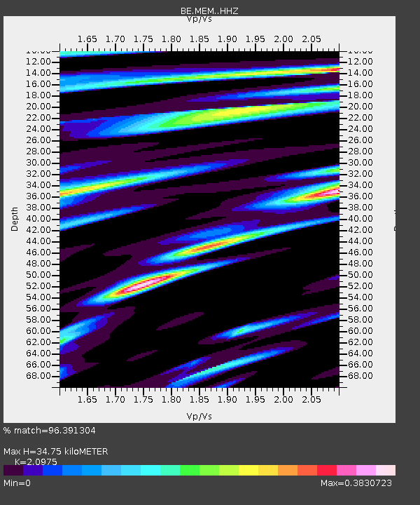
| Estimated Moho Depth: |
34.75 km |
| Estimated Crust Vp/Vs: |
2.10 |
| Assumed Crust Vp: |
6.276 km/s |
| Estimated Crust Vs: |
2.992 km/s |
| Estimated Crust Poisson's Ratio: |
0.35 |
|
| Radial Match: |
96.391304 % |
| Radial Bump: |
248 |
| Transverse Match: |
76.03723 % |
| Transverse Bump: |
400 |
| SOD ConfigId: |
13570011 |
| Insert Time: |
2019-04-30 19:28:33.471 +0000 |
| GWidth: |
2.5 |
| Max Bumps: |
400 |
| Tol: |
0.001 |
|

Signal To Noise
| Channel | StoN | STA | LTA |
| BE:MEM: :HHZ:20180815T22:08:21.527986Z | 35.104614 | 2.7408273E-6 | 7.8075985E-8 |
| BE:MEM: :HHN:20180815T22:08:21.527986Z | 15.942843 | 1.0574017E-6 | 6.632454E-8 |
| BE:MEM: :HHE:20180815T22:08:21.527986Z | 1.5395213 | 9.9233446E-8 | 6.445734E-8 |
| Arrivals |
| Ps | 6.2 SECOND |
| PpPs | 17 SECOND |
| PsPs/PpSs | 23 SECOND |


