You are here: Home > Network List > CC - Cascade Chain Volcano Monitoring Stations List
> Station CIHL Cinder Hill, Newberry, OR > Earthquake Result Viewer
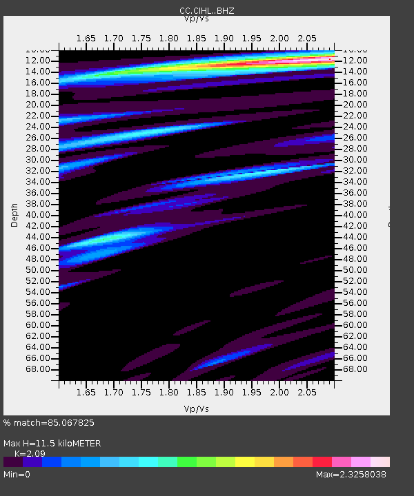
CIHL Cinder Hill, Newberry, OR - Earthquake Result Viewer
| Earthquake location: |
Andreanof Islands, Aleutian Is. |
| Earthquake latitude/longitude: |
51.4/-178.1 |
| Earthquake time(UTC): |
2018/08/15 (227) 21:56:54 GMT |
| Earthquake Depth: |
20 km |
| Earthquake Magnitude: |
6.6 Mww |
| Earthquake Catalog/Contributor: |
NEIC PDE/us |
|
| Network: |
CC Cascade Chain Volcano Monitoring |
| Station: |
CIHL Cinder Hill, Newberry, OR |
| Lat/Lon: |
43.75 N/121.15 W |
| Elevation: |
1966 m |
|
| Distance: |
38.3 deg |
| Az: |
78.567 deg |
| Baz: |
302.151 deg |
| Ray Param: |
0.0756322 |
| Estimated Moho Depth: |
11.5 km |
| Estimated Crust Vp/Vs: |
2.09 |
| Assumed Crust Vp: |
6.597 km/s |
| Estimated Crust Vs: |
3.157 km/s |
| Estimated Crust Poisson's Ratio: |
0.35 |
|
| Radial Match: |
85.067825 % |
| Radial Bump: |
400 |
| Transverse Match: |
76.30884 % |
| Transverse Bump: |
400 |
| SOD ConfigId: |
13570011 |
| Insert Time: |
2019-04-30 19:29:04.828 +0000 |
| GWidth: |
2.5 |
| Max Bumps: |
400 |
| Tol: |
0.001 |
|

Signal To Noise
| Channel | StoN | STA | LTA |
| CC:CIHL: :BHZ:20180815T22:03:42.500001Z | 8.51615 | 1.5330219E-6 | 1.8001349E-7 |
| CC:CIHL: :BHN:20180815T22:03:42.500001Z | 1.0157422 | 5.994913E-7 | 5.902002E-7 |
| CC:CIHL: :BHE:20180815T22:03:42.500001Z | 3.0586276 | 1.0732593E-6 | 3.5089573E-7 |
| Arrivals |
| Ps | 2.0 SECOND |
| PpPs | 5.0 SECOND |
| PsPs/PpSs | 7.1 SECOND |


