You are here: Home > Network List > TA - USArray Transportable Network (new EarthScope stations) Stations List
> Station U21A Nageezi, NM, USA > Earthquake Result Viewer
U21A Nageezi, NM, USA - Earthquake Result Viewer

| Earthquake location: |
Kuril Islands |
| Earthquake latitude/longitude: |
48.3/154.2 |
| Earthquake time(UTC): |
2009/09/10 (253) 02:46:50 GMT |
| Earthquake Depth: |
36 km |
| Earthquake Magnitude: |
6.0 MB, 5.5 MS, 6.0 MW, 5.8 MW |
| Earthquake Catalog/Contributor: |
WHDF/NEIC |
|
| Network: |
TA USArray Transportable Network (new EarthScope stations) |
| Station: |
U21A Nageezi, NM, USA |
| Lat/Lon: |
36.43 N/107.66 W |
| Elevation: |
2124 m |
|
| Distance: |
68.7 deg |
| Az: |
58.996 deg |
| Baz: |
314.814 deg |
| Ray Param: |
0.05610083 |
| Estimated Moho Depth: |
14.5 km |
| Estimated Crust Vp/Vs: |
2.09 |
| Assumed Crust Vp: |
6.159 km/s |
| Estimated Crust Vs: |
2.954 km/s |
| Estimated Crust Poisson's Ratio: |
0.35 |
|
| Radial Match: |
80.21332 % |
| Radial Bump: |
400 |
| Transverse Match: |
65.49755 % |
| Transverse Bump: |
400 |
| SOD ConfigId: |
2622 |
| Insert Time: |
2010-03-06 13:51:41.000 +0000 |
| GWidth: |
2.5 |
| Max Bumps: |
400 |
| Tol: |
0.001 |
|
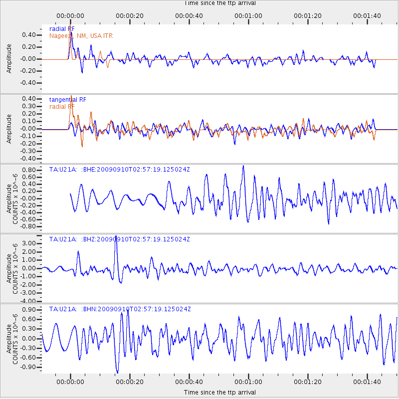
Signal To Noise
| Channel | StoN | STA | LTA |
| TA:U21A: :BHZ:20090910T02:57:19.125024Z | 4.675648 | 7.9400075E-7 | 1.6981619E-7 |
| TA:U21A: :BHN:20090910T02:57:19.125024Z | 1.7335705 | 3.23718E-7 | 1.8673485E-7 |
| TA:U21A: :BHE:20090910T02:57:19.125024Z | 1.4517275 | 2.4954196E-7 | 1.718931E-7 |
| Arrivals |
| Ps | 2.6 SECOND |
| PpPs | 7.1 SECOND |
| PsPs/PpSs | 9.7 SECOND |


