You are here: Home > Network List > CI - Caltech Regional Seismic Network Stations List
> Station PHL Parkhill, California, USA > Earthquake Result Viewer
PHL Parkhill, California, USA - Earthquake Result Viewer
| Earthquake location: |
New Britain Region, P.N.G. |
| Earthquake latitude/longitude: |
-6.0/148.8 |
| Earthquake time(UTC): |
1999/11/17 (321) 03:27:42 GMT |
| Earthquake Depth: |
48 km |
| Earthquake Magnitude: |
5.9 MB, 7.0 MS, 7.0 MW, 6.9 MW |
| Earthquake Catalog/Contributor: |
WHDF/NEIC |
|
| Network: |
CI Caltech Regional Seismic Network |
| Station: |
PHL Parkhill, California, USA |
| Lat/Lon: |
35.41 N/120.55 W |
| Elevation: |
351 m |
|
| Distance: |
93.9 deg |
| Az: |
54.961 deg |
| Baz: |
265.507 deg |
| Ray Param: |
0.041136842 |
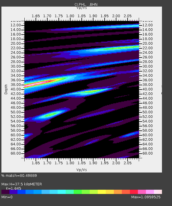
| Estimated Moho Depth: |
37.5 km |
| Estimated Crust Vp/Vs: |
1.64 |
| Assumed Crust Vp: |
6.183 km/s |
| Estimated Crust Vs: |
3.758 km/s |
| Estimated Crust Poisson's Ratio: |
0.21 |
|
| Radial Match: |
80.49889 % |
| Radial Bump: |
400 |
| Transverse Match: |
62.978527 % |
| Transverse Bump: |
400 |
| SOD ConfigId: |
3787 |
| Insert Time: |
2010-02-26 02:11:40.921 +0000 |
| GWidth: |
2.5 |
| Max Bumps: |
400 |
| Tol: |
0.001 |
|
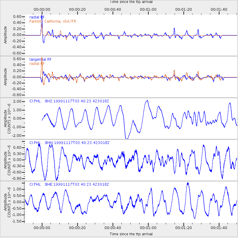
Signal To Noise
| Channel | StoN | STA | LTA |
| CI:PHL: :BHN:19991117T03:40:23.423018Z | 2.1986644 | 6.2421884E-7 | 2.839082E-7 |
| CI:PHL: :BHE:19991117T03:40:23.423018Z | 0.8001853 | 4.3712498E-7 | 5.4627964E-7 |
| CI:PHL: :BHZ:19991117T03:40:23.423018Z | 1.0553722 | 7.4620147E-7 | 7.070505E-7 |
| Arrivals |
| Ps | 4.0 SECOND |
| PpPs | 16 SECOND |
| PsPs/PpSs | 20 SECOND |


