You are here: Home > Network List > CI - Caltech Regional Seismic Network Stations List
> Station MPP McPhearson Peak > Earthquake Result Viewer
MPP McPhearson Peak - Earthquake Result Viewer
| Earthquake location: |
Andreanof Islands, Aleutian Is. |
| Earthquake latitude/longitude: |
51.4/-178.1 |
| Earthquake time(UTC): |
2018/08/15 (227) 21:56:54 GMT |
| Earthquake Depth: |
20 km |
| Earthquake Magnitude: |
6.6 Mww |
| Earthquake Catalog/Contributor: |
NEIC PDE/us |
|
| Network: |
CI Caltech Regional Seismic Network |
| Station: |
MPP McPhearson Peak |
| Lat/Lon: |
34.89 N/119.81 W |
| Elevation: |
1739 m |
|
| Distance: |
44.4 deg |
| Az: |
88.445 deg |
| Baz: |
310.433 deg |
| Ray Param: |
0.07193574 |
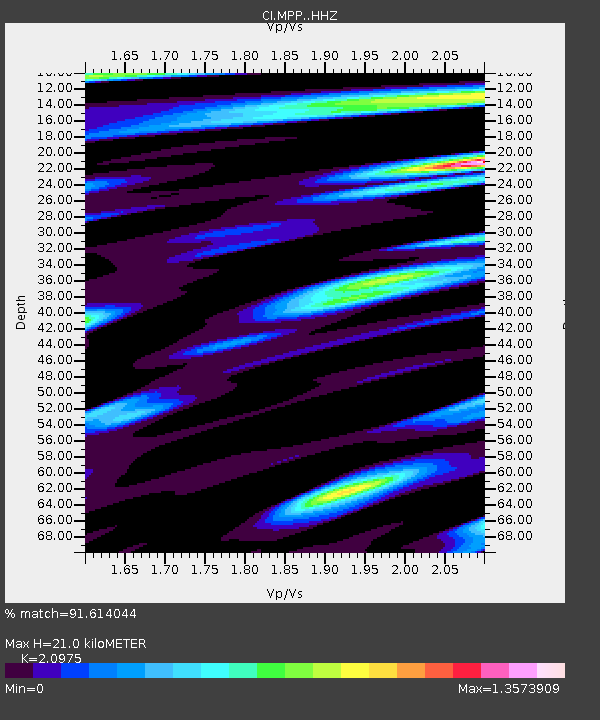
| Estimated Moho Depth: |
21.0 km |
| Estimated Crust Vp/Vs: |
2.10 |
| Assumed Crust Vp: |
6.1 km/s |
| Estimated Crust Vs: |
2.908 km/s |
| Estimated Crust Poisson's Ratio: |
0.35 |
|
| Radial Match: |
91.614044 % |
| Radial Bump: |
400 |
| Transverse Match: |
81.85043 % |
| Transverse Bump: |
400 |
| SOD ConfigId: |
13570011 |
| Insert Time: |
2019-04-30 19:29:50.336 +0000 |
| GWidth: |
2.5 |
| Max Bumps: |
400 |
| Tol: |
0.001 |
|

Signal To Noise
| Channel | StoN | STA | LTA |
| CI:MPP: :HHZ:20180815T22:04:32.42801Z | 5.239861 | 6.9287927E-7 | 1.3223237E-7 |
| CI:MPP: :HHN:20180815T22:04:32.42801Z | 1.8839025 | 5.9695674E-7 | 3.1687242E-7 |
| CI:MPP: :HHE:20180815T22:04:32.42801Z | 2.8239388 | 3.618823E-7 | 1.2814806E-7 |
| Arrivals |
| Ps | 4.0 SECOND |
| PpPs | 10 SECOND |
| PsPs/PpSs | 14 SECOND |


