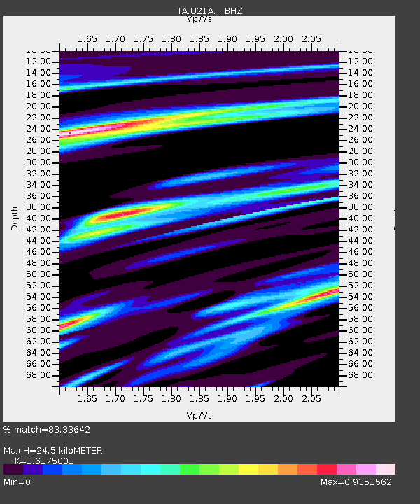
U21A Nageezi, NM, USA - Earthquake Result Viewer

Earthquake location: Kodiak Island Region, Alaska
Earthquake latitude/longitude: 56.5/-152.7
Earthquake time(UTC): 2009/03/30 (089) 07:13:07 GMT
Earthquake Depth: 21 km
Earthquake Magnitude: 5.9 MB, 5.9 MS, 5.9 MW, 5.9 MW
Earthquake Catalog/Contributor: WHDF/NEIC
Network: TA USArray Transportable Network (new EarthScope stations)
Station: U21A Nageezi, NM, USA
Lat/Lon: 36.43 N/107.66 W
Elevation: 2124 m
Distance: 36.1 deg
Az: 104.403 deg
Baz: 318.307 deg
Ray Param: 0.0768192
Estimated Moho Depth: 24.5 km
Estimated Crust Vp/Vs: 1.62
Assumed Crust Vp: 6.159 km/s
Estimated Crust Vs: 3.808 km/s
Estimated Crust Poisson's Ratio: 0.19
Radial Match: 83.33642 %
Radial Bump: 400
Transverse Match: 64.05427 %
Transverse Bump: 400
SOD ConfigId: 2658
Insert Time: 2010-03-06 13:52:14.902 +0000
GWidth: 2.5
Max Bumps: 400
Tol: 0.001

Signal To Noise

ChannelStoNSTALTA
TA:U21A: :BHZ:20090330T07:19:37.174012Z9.1969761.6495741E-61.7936048E-7
TA:U21A: :BHN:20090330T07:19:37.174012Z3.23386365.6721365E-71.7539814E-7
TA:U21A: :BHE:20090330T07:19:37.174012Z2.87545856.0856917E-72.1164247E-7
Arrivals
Ps2.6 SECOND
PpPs9.7 SECOND
PsPs/PpSs12 SECOND