You are here: Home > Network List > US - United States National Seismic Network Stations List
> Station MNTX Cornudas Mountains, Texas, USA > Earthquake Result Viewer
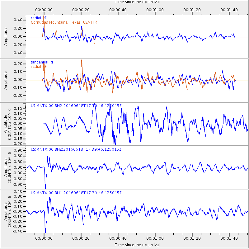
MNTX Cornudas Mountains, Texas, USA - Earthquake Result Viewer
*The percent match for this event was below the threshold and hence no stack was calculated.
| Earthquake location: |
Chile-Argentina Border Region |
| Earthquake latitude/longitude: |
-24.2/-67.1 |
| Earthquake time(UTC): |
2016/06/18 (170) 17:29:44 GMT |
| Earthquake Depth: |
167 km |
| Earthquake Magnitude: |
5.5 MB |
| Earthquake Catalog/Contributor: |
NEIC PDE/NEIC COMCAT |
|
| Network: |
US United States National Seismic Network |
| Station: |
MNTX Cornudas Mountains, Texas, USA |
| Lat/Lon: |
31.70 N/105.38 W |
| Elevation: |
404 m |
|
| Distance: |
66.6 deg |
| Az: |
324.852 deg |
| Baz: |
141.927 deg |
| Ray Param: |
$rayparam |
*The percent match for this event was below the threshold and hence was not used in the summary stack. |
|
| Radial Match: |
59.717968 % |
| Radial Bump: |
400 |
| Transverse Match: |
47.941135 % |
| Transverse Bump: |
400 |
| SOD ConfigId: |
1634031 |
| Insert Time: |
2016-07-02 17:36:24.107 +0000 |
| GWidth: |
2.5 |
| Max Bumps: |
400 |
| Tol: |
0.001 |
|
Signal To Noise
| Channel | StoN | STA | LTA |
| US:MNTX:00:BHZ:20160618T17:39:46.125015Z | 5.6037383 | 3.6518045E-7 | 6.516729E-8 |
| US:MNTX:00:BH1:20160618T17:39:46.125015Z | 2.506171 | 1.6896136E-7 | 6.7418135E-8 |
| US:MNTX:00:BH2:20160618T17:39:46.125015Z | 1.789724 | 8.506395E-8 | 4.7529088E-8 |
| Arrivals |
| Ps | |
| PpPs | |
| PsPs/PpSs | |


