You are here: Home > Network List > GB - Great Britain Seismograph Network Stations List
> Station DRUM DRUMTOCHTY, SCOTLAND > Earthquake Result Viewer
DRUM DRUMTOCHTY, SCOTLAND - Earthquake Result Viewer
| Earthquake location: |
Andreanof Islands, Aleutian Is. |
| Earthquake latitude/longitude: |
51.4/-178.1 |
| Earthquake time(UTC): |
2018/08/15 (227) 21:56:54 GMT |
| Earthquake Depth: |
20 km |
| Earthquake Magnitude: |
6.6 Mww |
| Earthquake Catalog/Contributor: |
NEIC PDE/us |
|
| Network: |
GB Great Britain Seismograph Network |
| Station: |
DRUM DRUMTOCHTY, SCOTLAND |
| Lat/Lon: |
56.91 N/2.49 W |
| Elevation: |
208 m |
|
| Distance: |
72.0 deg |
| Az: |
2.555 deg |
| Baz: |
357.084 deg |
| Ray Param: |
0.053963054 |
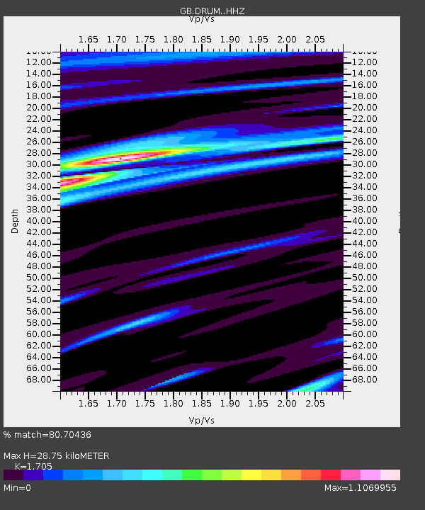
| Estimated Moho Depth: |
28.75 km |
| Estimated Crust Vp/Vs: |
1.71 |
| Assumed Crust Vp: |
6.276 km/s |
| Estimated Crust Vs: |
3.681 km/s |
| Estimated Crust Poisson's Ratio: |
0.24 |
|
| Radial Match: |
80.70436 % |
| Radial Bump: |
400 |
| Transverse Match: |
58.421017 % |
| Transverse Bump: |
400 |
| SOD ConfigId: |
13570011 |
| Insert Time: |
2019-04-30 19:31:24.657 +0000 |
| GWidth: |
2.5 |
| Max Bumps: |
400 |
| Tol: |
0.001 |
|

Signal To Noise
| Channel | StoN | STA | LTA |
| GB:DRUM: :HHZ:20180815T22:07:45.209993Z | 9.194243 | 2.6243738E-6 | 2.8543664E-7 |
| GB:DRUM: :HHN:20180815T22:07:45.209993Z | 3.3910356 | 1.0053044E-6 | 2.964594E-7 |
| GB:DRUM: :HHE:20180815T22:07:45.209993Z | 1.4883353 | 4.53584E-7 | 3.0475928E-7 |
| Arrivals |
| Ps | 3.3 SECOND |
| PpPs | 12 SECOND |
| PsPs/PpSs | 15 SECOND |


