You are here: Home > Network List > KO - Kandilli Observatory Digital Broadband Seismic Network Stations List
> Station BZK Bozkurt-Kastamonu-Turkey > Earthquake Result Viewer
BZK Bozkurt-Kastamonu-Turkey - Earthquake Result Viewer
| Earthquake location: |
Andreanof Islands, Aleutian Is. |
| Earthquake latitude/longitude: |
51.4/-178.1 |
| Earthquake time(UTC): |
2018/08/15 (227) 21:56:54 GMT |
| Earthquake Depth: |
20 km |
| Earthquake Magnitude: |
6.6 Mww |
| Earthquake Catalog/Contributor: |
NEIC PDE/us |
|
| Network: |
KO Kandilli Observatory Digital Broadband Seismic Network |
| Station: |
BZK Bozkurt-Kastamonu-Turkey |
| Lat/Lon: |
41.96 N/34.00 E |
| Elevation: |
158 m |
|
| Distance: |
82.9 deg |
| Az: |
336.488 deg |
| Baz: |
19.562 deg |
| Ray Param: |
0.046556875 |
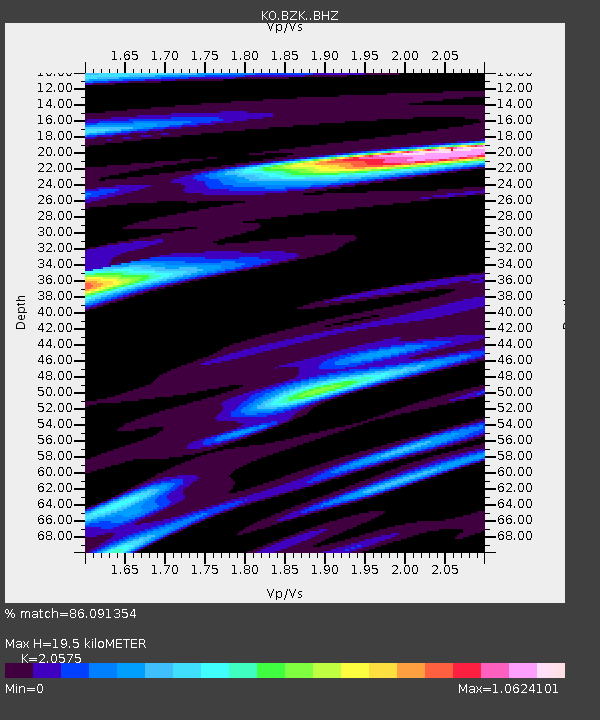
| Estimated Moho Depth: |
19.5 km |
| Estimated Crust Vp/Vs: |
2.06 |
| Assumed Crust Vp: |
6.419 km/s |
| Estimated Crust Vs: |
3.12 km/s |
| Estimated Crust Poisson's Ratio: |
0.35 |
|
| Radial Match: |
86.091354 % |
| Radial Bump: |
400 |
| Transverse Match: |
79.11424 % |
| Transverse Bump: |
400 |
| SOD ConfigId: |
13570011 |
| Insert Time: |
2019-04-30 19:33:04.919 +0000 |
| GWidth: |
2.5 |
| Max Bumps: |
400 |
| Tol: |
0.001 |
|

Signal To Noise
| Channel | StoN | STA | LTA |
| KO:BZK: :BHZ:20180815T22:08:46.160005Z | 10.034089 | 8.258265E-6 | 8.2302086E-7 |
| KO:BZK: :BHN:20180815T22:08:46.160005Z | 4.4048786 | 3.2313055E-6 | 7.335742E-7 |
| KO:BZK: :BHE:20180815T22:08:46.160005Z | 1.0373437 | 5.577032E-7 | 5.3762625E-7 |
| Arrivals |
| Ps | 3.3 SECOND |
| PpPs | 9.1 SECOND |
| PsPs/PpSs | 12 SECOND |


