You are here: Home > Network List > TA - USArray Transportable Network (new EarthScope stations) Stations List
> Station U21A Nageezi, NM, USA > Earthquake Result Viewer
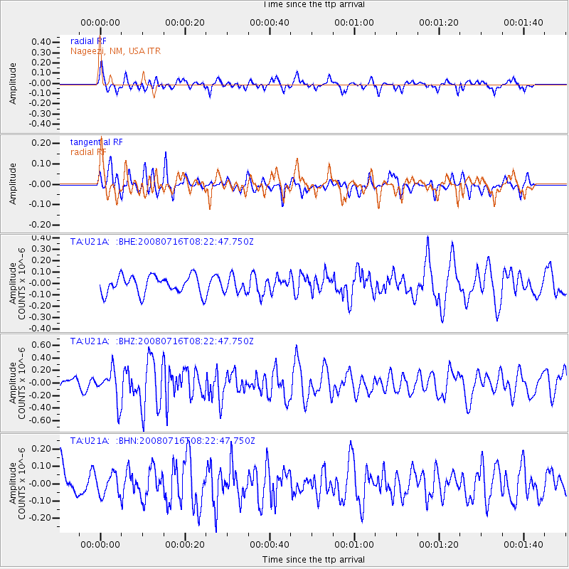
U21A Nageezi, NM, USA - Earthquake Result Viewer
*The percent match for this event was below the threshold and hence no stack was calculated.
| Earthquake location: |
Samoa Islands Region |
| Earthquake latitude/longitude: |
-16.6/-173.0 |
| Earthquake time(UTC): |
2008/07/16 (198) 08:11:04 GMT |
| Earthquake Depth: |
10 km |
| Earthquake Magnitude: |
5.5 MB, 5.4 MS, 5.7 MW, 5.7 MW |
| Earthquake Catalog/Contributor: |
WHDF/NEIC |
|
| Network: |
TA USArray Transportable Network (new EarthScope stations) |
| Station: |
U21A Nageezi, NM, USA |
| Lat/Lon: |
36.43 N/107.66 W |
| Elevation: |
2124 m |
|
| Distance: |
81.1 deg |
| Az: |
47.88 deg |
| Baz: |
241.866 deg |
| Ray Param: |
$rayparam |
*The percent match for this event was below the threshold and hence was not used in the summary stack. |
|
| Radial Match: |
64.66452 % |
| Radial Bump: |
400 |
| Transverse Match: |
46.90021 % |
| Transverse Bump: |
326 |
| SOD ConfigId: |
2504 |
| Insert Time: |
2010-03-06 13:52:51.118 +0000 |
| GWidth: |
2.5 |
| Max Bumps: |
400 |
| Tol: |
0.001 |
|
Signal To Noise
| Channel | StoN | STA | LTA |
| TA:U21A: :BHZ:20080716T08:22:47.750Z | 2.4173188 | 2.588037E-7 | 1.070623E-7 |
| TA:U21A: :BHN:20080716T08:22:47.750Z | 0.49965656 | 6.063267E-8 | 1.2134869E-7 |
| TA:U21A: :BHE:20080716T08:22:47.750Z | 0.8971848 | 7.1434776E-8 | 7.962103E-8 |
| Arrivals |
| Ps | |
| PpPs | |
| PsPs/PpSs | |


