You are here: Home > Network List > TA - USArray Transportable Network (new EarthScope stations) Stations List
> Station U21A Nageezi, NM, USA > Earthquake Result Viewer
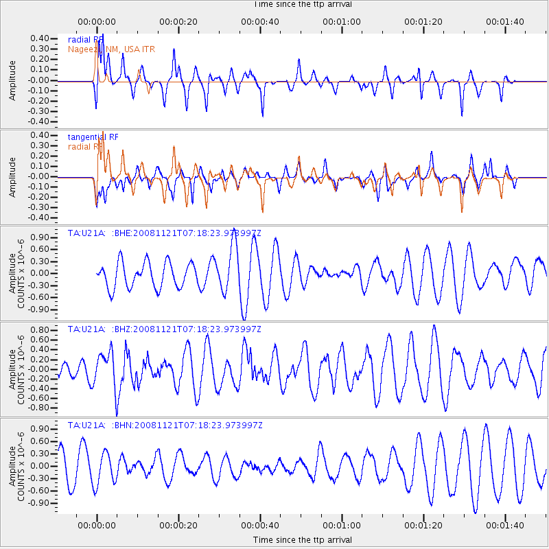
U21A Nageezi, NM, USA - Earthquake Result Viewer
*The percent match for this event was below the threshold and hence no stack was calculated.
| Earthquake location: |
Solomon Islands |
| Earthquake latitude/longitude: |
-8.9/159.6 |
| Earthquake time(UTC): |
2008/11/21 (326) 07:05:34 GMT |
| Earthquake Depth: |
118 km |
| Earthquake Magnitude: |
6.0 MB, 6.1 MW, 6.0 MW |
| Earthquake Catalog/Contributor: |
WHDF/NEIC |
|
| Network: |
TA USArray Transportable Network (new EarthScope stations) |
| Station: |
U21A Nageezi, NM, USA |
| Lat/Lon: |
36.43 N/107.66 W |
| Elevation: |
2124 m |
|
| Distance: |
97.5 deg |
| Az: |
54.337 deg |
| Baz: |
264.433 deg |
| Ray Param: |
$rayparam |
*The percent match for this event was below the threshold and hence was not used in the summary stack. |
|
| Radial Match: |
59.23976 % |
| Radial Bump: |
344 |
| Transverse Match: |
56.547432 % |
| Transverse Bump: |
341 |
| SOD ConfigId: |
2658 |
| Insert Time: |
2010-03-06 13:53:11.515 +0000 |
| GWidth: |
2.5 |
| Max Bumps: |
400 |
| Tol: |
0.001 |
|
Signal To Noise
| Channel | StoN | STA | LTA |
| TA:U21A: :BHZ:20081121T07:18:23.973997Z | 2.5449696 | 3.6499384E-7 | 1.4341776E-7 |
| TA:U21A: :BHN:20081121T07:18:23.973997Z | 1.1913472 | 3.8512826E-7 | 3.2327122E-7 |
| TA:U21A: :BHE:20081121T07:18:23.973997Z | 1.8840034 | 5.830113E-7 | 3.094534E-7 |
| Arrivals |
| Ps | |
| PpPs | |
| PsPs/PpSs | |


