You are here: Home > Network List > N4 - Central and EAstern US Network Stations List
> Station F33B 5 Mile Ranch, Herman, MN, USA > Earthquake Result Viewer
F33B 5 Mile Ranch, Herman, MN, USA - Earthquake Result Viewer
| Earthquake location: |
Andreanof Islands, Aleutian Is. |
| Earthquake latitude/longitude: |
51.4/-178.1 |
| Earthquake time(UTC): |
2018/08/15 (227) 21:56:54 GMT |
| Earthquake Depth: |
20 km |
| Earthquake Magnitude: |
6.6 Mww |
| Earthquake Catalog/Contributor: |
NEIC PDE/us |
|
| Network: |
N4 Central and EAstern US Network |
| Station: |
F33B 5 Mile Ranch, Herman, MN, USA |
| Lat/Lon: |
45.84 N/96.29 W |
| Elevation: |
314 m |
|
| Distance: |
51.7 deg |
| Az: |
61.896 deg |
| Baz: |
307.829 deg |
| Ray Param: |
0.06724423 |
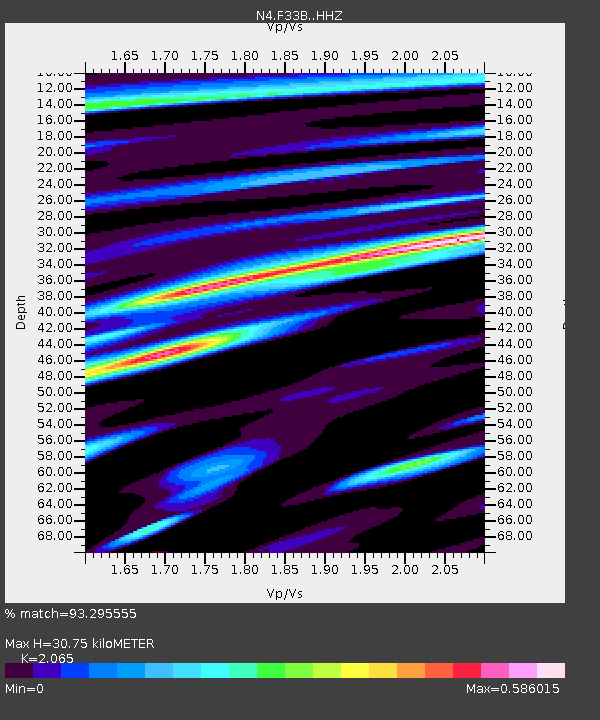
| Estimated Moho Depth: |
30.75 km |
| Estimated Crust Vp/Vs: |
2.07 |
| Assumed Crust Vp: |
6.552 km/s |
| Estimated Crust Vs: |
3.173 km/s |
| Estimated Crust Poisson's Ratio: |
0.35 |
|
| Radial Match: |
93.295555 % |
| Radial Bump: |
308 |
| Transverse Match: |
65.60403 % |
| Transverse Bump: |
400 |
| SOD ConfigId: |
13570011 |
| Insert Time: |
2019-04-30 19:34:49.051 +0000 |
| GWidth: |
2.5 |
| Max Bumps: |
400 |
| Tol: |
0.001 |
|

Signal To Noise
| Channel | StoN | STA | LTA |
| N4:F33B: :HHZ:20180815T22:05:28.80002Z | 37.64321 | 2.25603E-6 | 5.993192E-8 |
| N4:F33B: :HHN:20180815T22:05:28.80002Z | 19.895388 | 7.7260705E-7 | 3.8833477E-8 |
| N4:F33B: :HHE:20180815T22:05:28.80002Z | 16.795778 | 9.512443E-7 | 5.6635916E-8 |
| Arrivals |
| Ps | 5.3 SECOND |
| PpPs | 14 SECOND |
| PsPs/PpSs | 19 SECOND |


