You are here: Home > Network List > TA - USArray Transportable Network (new EarthScope stations) Stations List
> Station U21A Nageezi, NM, USA > Earthquake Result Viewer
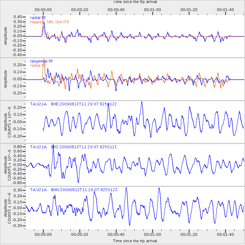
U21A Nageezi, NM, USA - Earthquake Result Viewer
*The percent match for this event was below the threshold and hence no stack was calculated.
| Earthquake location: |
Tonga Islands |
| Earthquake latitude/longitude: |
-21.7/-174.6 |
| Earthquake time(UTC): |
2009/08/13 (225) 11:17:01 GMT |
| Earthquake Depth: |
10 km |
| Earthquake Magnitude: |
5.6 MW, 5.3 MB |
| Earthquake Catalog/Contributor: |
WHDF/NEIC |
|
| Network: |
TA USArray Transportable Network (new EarthScope stations) |
| Station: |
U21A Nageezi, NM, USA |
| Lat/Lon: |
36.43 N/107.66 W |
| Elevation: |
2124 m |
|
| Distance: |
85.6 deg |
| Az: |
48.082 deg |
| Baz: |
239.121 deg |
| Ray Param: |
$rayparam |
*The percent match for this event was below the threshold and hence was not used in the summary stack. |
|
| Radial Match: |
75.58661 % |
| Radial Bump: |
400 |
| Transverse Match: |
66.46381 % |
| Transverse Bump: |
400 |
| SOD ConfigId: |
2622 |
| Insert Time: |
2010-03-06 13:53:25.341 +0000 |
| GWidth: |
2.5 |
| Max Bumps: |
400 |
| Tol: |
0.001 |
|
Signal To Noise
| Channel | StoN | STA | LTA |
| TA:U21A: :BHZ:20090813T11:29:07.825012Z | 2.9904444 | 1.9910844E-7 | 6.6581556E-8 |
| TA:U21A: :BHN:20090813T11:29:07.825012Z | 1.283736 | 6.101903E-8 | 4.753238E-8 |
| TA:U21A: :BHE:20090813T11:29:07.825012Z | 0.9711826 | 7.655392E-8 | 7.8825465E-8 |
| Arrivals |
| Ps | |
| PpPs | |
| PsPs/PpSs | |


