You are here: Home > Network List > UU - University of Utah Regional Network Stations List
> Station FORU South Mineral Mountains, UT, USA > Earthquake Result Viewer
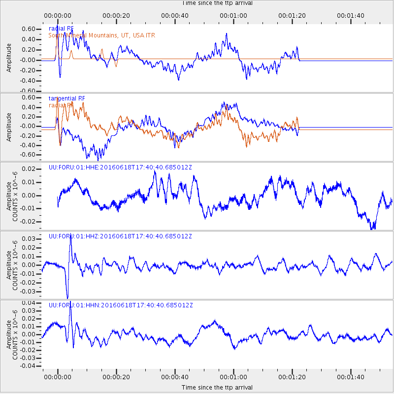
FORU South Mineral Mountains, UT, USA - Earthquake Result Viewer
*The percent match for this event was below the threshold and hence no stack was calculated.
| Earthquake location: |
Chile-Argentina Border Region |
| Earthquake latitude/longitude: |
-24.2/-67.1 |
| Earthquake time(UTC): |
2016/06/18 (170) 17:29:44 GMT |
| Earthquake Depth: |
167 km |
| Earthquake Magnitude: |
5.5 MB |
| Earthquake Catalog/Contributor: |
NEIC PDE/NEIC COMCAT |
|
| Network: |
UU University of Utah Regional Network |
| Station: |
FORU South Mineral Mountains, UT, USA |
| Lat/Lon: |
38.46 N/112.86 W |
| Elevation: |
1840 m |
|
| Distance: |
75.7 deg |
| Az: |
324.505 deg |
| Baz: |
137.524 deg |
| Ray Param: |
$rayparam |
*The percent match for this event was below the threshold and hence was not used in the summary stack. |
|
| Radial Match: |
54.55032 % |
| Radial Bump: |
323 |
| Transverse Match: |
60.456238 % |
| Transverse Bump: |
400 |
| SOD ConfigId: |
1634031 |
| Insert Time: |
2016-07-02 17:36:58.114 +0000 |
| GWidth: |
2.5 |
| Max Bumps: |
400 |
| Tol: |
0.001 |
|
Signal To Noise
| Channel | StoN | STA | LTA |
| UU:FORU:01:HHZ:20160618T17:40:40.685012Z | 5.9662023 | 1.6449134E-8 | 2.7570524E-9 |
| UU:FORU:01:HHN:20160618T17:40:40.685012Z | 6.7455688 | 2.1249994E-8 | 3.1502154E-9 |
| UU:FORU:01:HHE:20160618T17:40:40.685012Z | 1.3782514 | 8.8091205E-9 | 6.391519E-9 |
| Arrivals |
| Ps | |
| PpPs | |
| PsPs/PpSs | |


