You are here: Home > Network List > N4 - Central and EAstern US Network Stations List
> Station S57A Dark Hallow, Roseland, VA, USA > Earthquake Result Viewer
S57A Dark Hallow, Roseland, VA, USA - Earthquake Result Viewer
| Earthquake location: |
Andreanof Islands, Aleutian Is. |
| Earthquake latitude/longitude: |
51.4/-178.1 |
| Earthquake time(UTC): |
2018/08/15 (227) 21:56:54 GMT |
| Earthquake Depth: |
20 km |
| Earthquake Magnitude: |
6.6 Mww |
| Earthquake Catalog/Contributor: |
NEIC PDE/us |
|
| Network: |
N4 Central and EAstern US Network |
| Station: |
S57A Dark Hallow, Roseland, VA, USA |
| Lat/Lon: |
37.76 N/78.95 W |
| Elevation: |
264 m |
|
| Distance: |
66.6 deg |
| Az: |
58.505 deg |
| Baz: |
317.666 deg |
| Ray Param: |
0.05748489 |
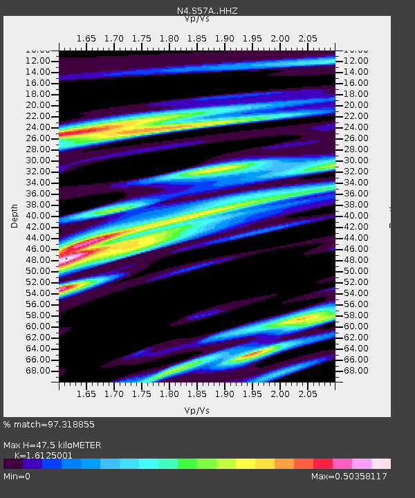
| Estimated Moho Depth: |
47.5 km |
| Estimated Crust Vp/Vs: |
1.61 |
| Assumed Crust Vp: |
6.419 km/s |
| Estimated Crust Vs: |
3.981 km/s |
| Estimated Crust Poisson's Ratio: |
0.19 |
|
| Radial Match: |
97.318855 % |
| Radial Bump: |
315 |
| Transverse Match: |
84.22745 % |
| Transverse Bump: |
400 |
| SOD ConfigId: |
13570011 |
| Insert Time: |
2019-04-30 19:35:48.963 +0000 |
| GWidth: |
2.5 |
| Max Bumps: |
400 |
| Tol: |
0.001 |
|

Signal To Noise
| Channel | StoN | STA | LTA |
| N4:S57A: :HHZ:20180815T22:07:12.120027Z | 67.57355 | 3.3697752E-6 | 4.986826E-8 |
| N4:S57A: :HHN:20180815T22:07:12.120027Z | 17.954468 | 1.0300068E-6 | 5.7367714E-8 |
| N4:S57A: :HHE:20180815T22:07:12.120027Z | 19.058537 | 1.0684689E-6 | 5.6062483E-8 |
| Arrivals |
| Ps | 4.7 SECOND |
| PpPs | 18 SECOND |
| PsPs/PpSs | 23 SECOND |


