You are here: Home > Network List > N4 - Central and EAstern US Network Stations List
> Station S61A Accomac, VA, USA > Earthquake Result Viewer
S61A Accomac, VA, USA - Earthquake Result Viewer
| Earthquake location: |
Andreanof Islands, Aleutian Is. |
| Earthquake latitude/longitude: |
51.4/-178.1 |
| Earthquake time(UTC): |
2018/08/15 (227) 21:56:54 GMT |
| Earthquake Depth: |
20 km |
| Earthquake Magnitude: |
6.6 Mww |
| Earthquake Catalog/Contributor: |
NEIC PDE/us |
|
| Network: |
N4 Central and EAstern US Network |
| Station: |
S61A Accomac, VA, USA |
| Lat/Lon: |
37.68 N/75.67 W |
| Elevation: |
58 m |
|
| Distance: |
68.4 deg |
| Az: |
56.461 deg |
| Baz: |
318.883 deg |
| Ray Param: |
0.05631103 |
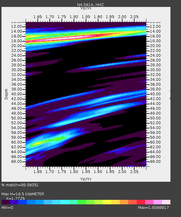
| Estimated Moho Depth: |
16.5 km |
| Estimated Crust Vp/Vs: |
1.77 |
| Assumed Crust Vp: |
5.817 km/s |
| Estimated Crust Vs: |
3.282 km/s |
| Estimated Crust Poisson's Ratio: |
0.27 |
|
| Radial Match: |
88.06051 % |
| Radial Bump: |
332 |
| Transverse Match: |
65.96343 % |
| Transverse Bump: |
400 |
| SOD ConfigId: |
13570011 |
| Insert Time: |
2019-04-30 19:35:51.704 +0000 |
| GWidth: |
2.5 |
| Max Bumps: |
400 |
| Tol: |
0.001 |
|
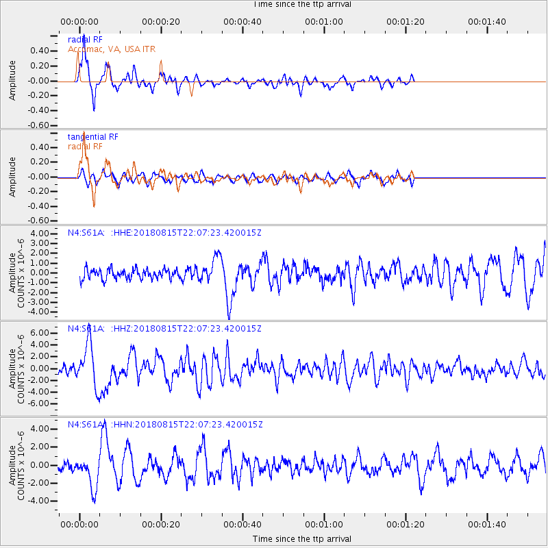
Signal To Noise
| Channel | StoN | STA | LTA |
| N4:S61A: :HHZ:20180815T22:07:23.420015Z | 7.232141 | 3.8134963E-6 | 5.2729837E-7 |
| N4:S61A: :HHN:20180815T22:07:23.420015Z | 3.5482318 | 1.7912081E-6 | 5.0481714E-7 |
| N4:S61A: :HHE:20180815T22:07:23.420015Z | 2.7408984 | 1.3348914E-6 | 4.870269E-7 |
| Arrivals |
| Ps | 2.3 SECOND |
| PpPs | 7.6 SECOND |
| PsPs/PpSs | 9.9 SECOND |


