You are here: Home > Network List > O2 - Oklahoma Consolidated Temporary Seismic Networks Stations List
> Station SHWN Shawnee, Oklahoma, USA > Earthquake Result Viewer
SHWN Shawnee, Oklahoma, USA - Earthquake Result Viewer
| Earthquake location: |
Andreanof Islands, Aleutian Is. |
| Earthquake latitude/longitude: |
51.4/-178.1 |
| Earthquake time(UTC): |
2018/08/15 (227) 21:56:54 GMT |
| Earthquake Depth: |
20 km |
| Earthquake Magnitude: |
6.6 Mww |
| Earthquake Catalog/Contributor: |
NEIC PDE/us |
|
| Network: |
O2 Oklahoma Consolidated Temporary Seismic Networks |
| Station: |
SHWN Shawnee, Oklahoma, USA |
| Lat/Lon: |
35.34 N/97.02 W |
| Elevation: |
320 m |
|
| Distance: |
58.1 deg |
| Az: |
72.083 deg |
| Baz: |
313.236 deg |
| Ray Param: |
0.06306098 |
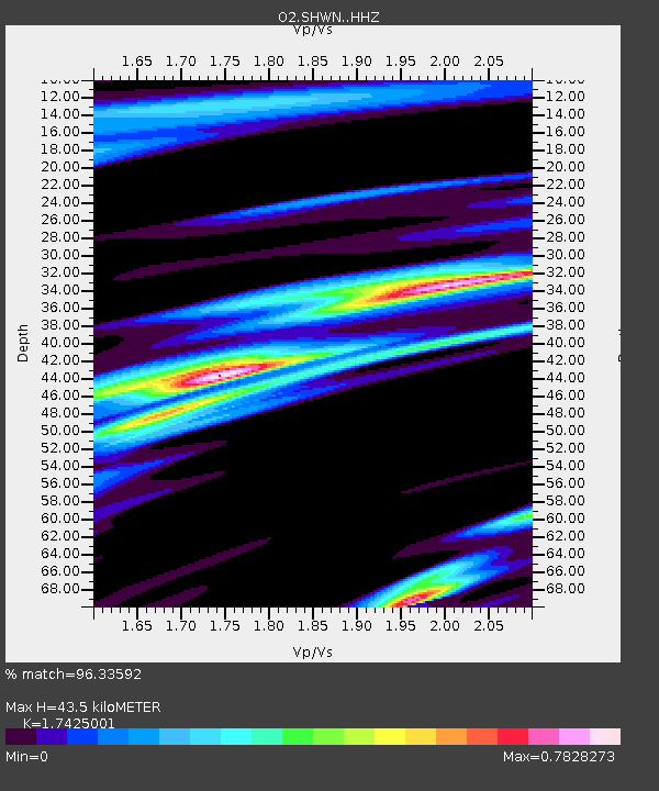
| Estimated Moho Depth: |
43.5 km |
| Estimated Crust Vp/Vs: |
1.74 |
| Assumed Crust Vp: |
6.426 km/s |
| Estimated Crust Vs: |
3.688 km/s |
| Estimated Crust Poisson's Ratio: |
0.25 |
|
| Radial Match: |
96.33592 % |
| Radial Bump: |
358 |
| Transverse Match: |
85.961494 % |
| Transverse Bump: |
400 |
| SOD ConfigId: |
13570011 |
| Insert Time: |
2019-04-30 19:37:11.771 +0000 |
| GWidth: |
2.5 |
| Max Bumps: |
400 |
| Tol: |
0.001 |
|

Signal To Noise
| Channel | StoN | STA | LTA |
| O2:SHWN: :HHZ:20180815T22:06:15.09897Z | 42.301624 | 3.6375907E-6 | 8.599175E-8 |
| O2:SHWN: :HH1:20180815T22:06:15.09897Z | 14.5611315 | 1.6673295E-6 | 1.1450548E-7 |
| O2:SHWN: :HH2:20180815T22:06:15.09897Z | 16.727205 | 1.5585167E-6 | 9.3172574E-8 |
| Arrivals |
| Ps | 5.3 SECOND |
| PpPs | 18 SECOND |
| PsPs/PpSs | 23 SECOND |


