You are here: Home > Network List > OK - Oklahoma Seismic Network Stations List
> Station CSTR Hydro, Oklahoma, USA > Earthquake Result Viewer
CSTR Hydro, Oklahoma, USA - Earthquake Result Viewer
| Earthquake location: |
Andreanof Islands, Aleutian Is. |
| Earthquake latitude/longitude: |
51.4/-178.1 |
| Earthquake time(UTC): |
2018/08/15 (227) 21:56:54 GMT |
| Earthquake Depth: |
20 km |
| Earthquake Magnitude: |
6.6 Mww |
| Earthquake Catalog/Contributor: |
NEIC PDE/us |
|
| Network: |
OK Oklahoma Seismic Network |
| Station: |
CSTR Hydro, Oklahoma, USA |
| Lat/Lon: |
35.65 N/98.69 W |
| Elevation: |
516 m |
|
| Distance: |
56.9 deg |
| Az: |
72.92 deg |
| Baz: |
312.723 deg |
| Ray Param: |
0.063835435 |
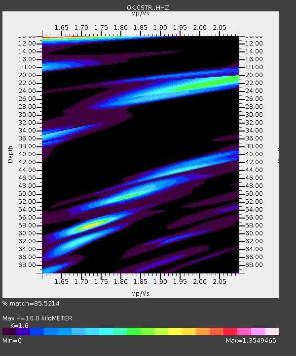
| Estimated Moho Depth: |
10.0 km |
| Estimated Crust Vp/Vs: |
1.60 |
| Assumed Crust Vp: |
6.315 km/s |
| Estimated Crust Vs: |
3.947 km/s |
| Estimated Crust Poisson's Ratio: |
0.18 |
|
| Radial Match: |
85.5214 % |
| Radial Bump: |
400 |
| Transverse Match: |
64.310585 % |
| Transverse Bump: |
400 |
| SOD ConfigId: |
13570011 |
| Insert Time: |
2019-04-30 19:37:20.185 +0000 |
| GWidth: |
2.5 |
| Max Bumps: |
400 |
| Tol: |
0.001 |
|

Signal To Noise
| Channel | StoN | STA | LTA |
| OK:CSTR: :HHZ:20180815T22:06:06.649995Z | 12.312221 | 4.1535014E-7 | 3.3734786E-8 |
| OK:CSTR: :HHN:20180815T22:06:06.649995Z | 3.6671858 | 1.1731094E-7 | 3.1989362E-8 |
| OK:CSTR: :HHE:20180815T22:06:06.649995Z | 3.2548826 | 1.12859894E-7 | 3.467403E-8 |
| Arrivals |
| Ps | 1.0 SECOND |
| PpPs | 3.9 SECOND |
| PsPs/PpSs | 4.9 SECOND |


