You are here: Home > Network List > TA - USArray Transportable Network (new EarthScope stations) Stations List
> Station U21A Nageezi, NM, USA > Earthquake Result Viewer
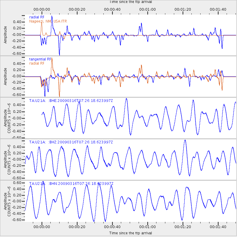
U21A Nageezi, NM, USA - Earthquake Result Viewer
*The percent match for this event was below the threshold and hence no stack was calculated.
| Earthquake location: |
Pacific-Antarctic Ridge |
| Earthquake latitude/longitude: |
-55.1/-129.7 |
| Earthquake time(UTC): |
2009/03/16 (075) 07:13:36 GMT |
| Earthquake Depth: |
10 km |
| Earthquake Magnitude: |
5.9 MW, 5.2 MS, 5.1 MB, 5.9 MW |
| Earthquake Catalog/Contributor: |
WHDF/NEIC |
|
| Network: |
TA USArray Transportable Network (new EarthScope stations) |
| Station: |
U21A Nageezi, NM, USA |
| Lat/Lon: |
36.43 N/107.66 W |
| Elevation: |
2124 m |
|
| Distance: |
93.1 deg |
| Az: |
17.646 deg |
| Baz: |
192.461 deg |
| Ray Param: |
$rayparam |
*The percent match for this event was below the threshold and hence was not used in the summary stack. |
|
| Radial Match: |
74.12303 % |
| Radial Bump: |
348 |
| Transverse Match: |
67.64586 % |
| Transverse Bump: |
323 |
| SOD ConfigId: |
2658 |
| Insert Time: |
2010-03-06 13:54:29.271 +0000 |
| GWidth: |
2.5 |
| Max Bumps: |
400 |
| Tol: |
0.001 |
|
Signal To Noise
| Channel | StoN | STA | LTA |
| TA:U21A: :BHZ:20090316T07:26:18.623997Z | 1.1971644 | 2.5401732E-7 | 2.1218247E-7 |
| TA:U21A: :BHN:20090316T07:26:18.623997Z | 1.3542119 | 3.9240996E-7 | 2.8976999E-7 |
| TA:U21A: :BHE:20090316T07:26:18.623997Z | 0.43569103 | 1.1491527E-7 | 2.6375403E-7 |
| Arrivals |
| Ps | |
| PpPs | |
| PsPs/PpSs | |


