You are here: Home > Network List > TA - USArray Transportable Network (new EarthScope stations) Stations List
> Station U21A Nageezi, NM, USA > Earthquake Result Viewer
U21A Nageezi, NM, USA - Earthquake Result Viewer
*The percent match for this event was below the threshold and hence no stack was calculated.
| Earthquake location: |
Western Brazil |
| Earthquake latitude/longitude: |
-8.1/-71.4 |
| Earthquake time(UTC): |
2009/01/29 (029) 22:28:05 GMT |
| Earthquake Depth: |
602 km |
| Earthquake Magnitude: |
5.7 MW, 5.3 MB, 5.6 MW |
| Earthquake Catalog/Contributor: |
WHDF/NEIC |
|
| Network: |
TA USArray Transportable Network (new EarthScope stations) |
| Station: |
U21A Nageezi, NM, USA |
| Lat/Lon: |
36.43 N/107.66 W |
| Elevation: |
2124 m |
|
| Distance: |
55.9 deg |
| Az: |
324.815 deg |
| Baz: |
134.975 deg |
| Ray Param: |
$rayparam |
*The percent match for this event was below the threshold and hence was not used in the summary stack. |
|
| Radial Match: |
54.266285 % |
| Radial Bump: |
400 |
| Transverse Match: |
52.779068 % |
| Transverse Bump: |
400 |
| SOD ConfigId: |
2658 |
| Insert Time: |
2010-03-06 13:54:44.543 +0000 |
| GWidth: |
2.5 |
| Max Bumps: |
400 |
| Tol: |
0.001 |
|
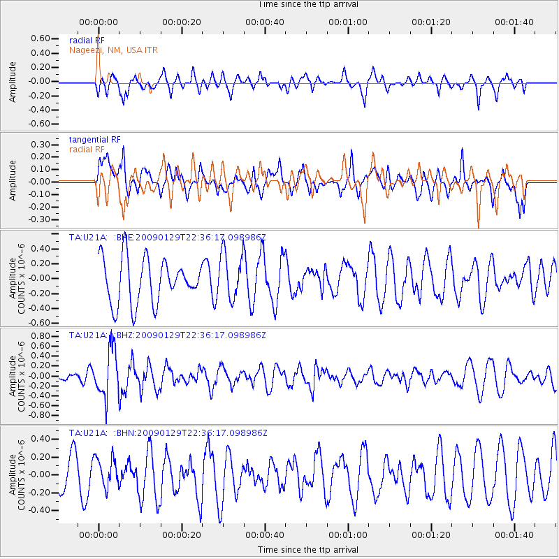
Signal To Noise
| Channel | StoN | STA | LTA |
| TA:U21A: :BHZ:20090129T22:36:17.098986Z | 3.8440442 | 4.900926E-7 | 1.27494E-7 |
| TA:U21A: :BHN:20090129T22:36:17.098986Z | 0.8979252 | 1.6895864E-7 | 1.881656E-7 |
| TA:U21A: :BHE:20090129T22:36:17.098986Z | 1.0605788 | 3.183415E-7 | 3.001583E-7 |
| Arrivals |
| Ps | |
| PpPs | |
| PsPs/PpSs | |


