You are here: Home > Network List > PR - Puerto Rico Seismic Network (PRSN) & Puerto Rico Strong Motion Program (PRSMP) Stations List
> Station MLPR Magueyes > Earthquake Result Viewer
MLPR Magueyes - Earthquake Result Viewer
| Earthquake location: |
Andreanof Islands, Aleutian Is. |
| Earthquake latitude/longitude: |
51.4/-178.1 |
| Earthquake time(UTC): |
2018/08/15 (227) 21:56:54 GMT |
| Earthquake Depth: |
20 km |
| Earthquake Magnitude: |
6.6 Mww |
| Earthquake Catalog/Contributor: |
NEIC PDE/us |
|
| Network: |
PR Puerto Rico Seismic Network (PRSN) & Puerto Rico Strong Motion Program (PRSMP) |
| Station: |
MLPR Magueyes |
| Lat/Lon: |
17.97 N/67.04 W |
| Elevation: |
0.0 m |
|
| Distance: |
88.5 deg |
| Az: |
62.727 deg |
| Baz: |
324.23 deg |
| Ray Param: |
0.042495374 |
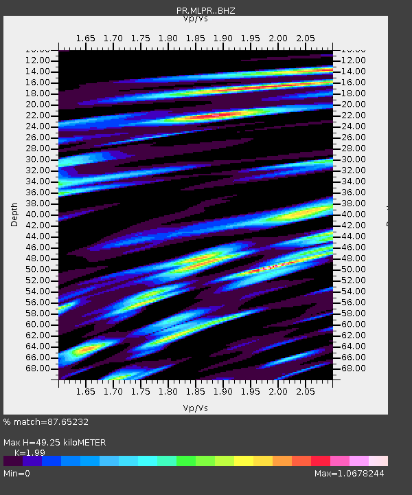
| Estimated Moho Depth: |
49.25 km |
| Estimated Crust Vp/Vs: |
1.99 |
| Assumed Crust Vp: |
4.082 km/s |
| Estimated Crust Vs: |
2.051 km/s |
| Estimated Crust Poisson's Ratio: |
0.33 |
|
| Radial Match: |
87.65232 % |
| Radial Bump: |
400 |
| Transverse Match: |
83.67728 % |
| Transverse Bump: |
400 |
| SOD ConfigId: |
13570011 |
| Insert Time: |
2019-04-30 19:38:31.577 +0000 |
| GWidth: |
2.5 |
| Max Bumps: |
400 |
| Tol: |
0.001 |
|

Signal To Noise
| Channel | StoN | STA | LTA |
| PR:MLPR: :BHZ:20180815T22:09:14.04001Z | 13.250611 | 2.891841E-6 | 2.1824206E-7 |
| PR:MLPR: :BHN:20180815T22:09:14.04001Z | 5.4850597 | 8.204244E-7 | 1.4957439E-7 |
| PR:MLPR: :BHE:20180815T22:09:14.04001Z | 2.2988603 | 5.499391E-7 | 2.3922252E-7 |
| Arrivals |
| Ps | 12 SECOND |
| PpPs | 36 SECOND |
| PsPs/PpSs | 48 SECOND |


