You are here: Home > Network List > TA - USArray Transportable Network (new EarthScope stations) Stations List
> Station U21A Nageezi, NM, USA > Earthquake Result Viewer
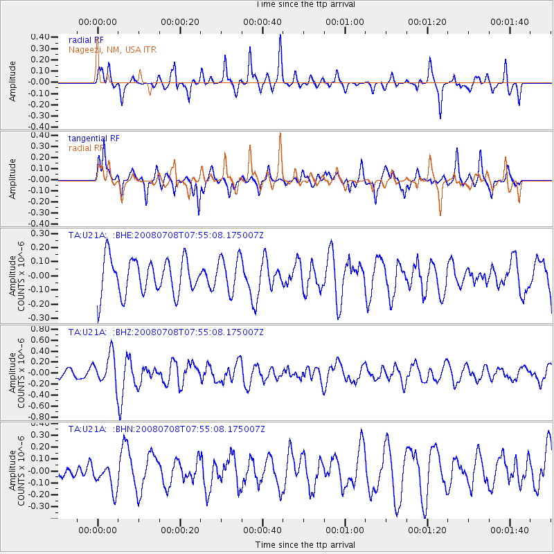
U21A Nageezi, NM, USA - Earthquake Result Viewer
*The percent match for this event was below the threshold and hence no stack was calculated.
| Earthquake location: |
Ryukyu Islands, Japan |
| Earthquake latitude/longitude: |
27.5/128.3 |
| Earthquake time(UTC): |
2008/07/08 (190) 07:42:10 GMT |
| Earthquake Depth: |
43 km |
| Earthquake Magnitude: |
6.0 MB, 5.5 MS, 6.0 MW, 6.0 MW |
| Earthquake Catalog/Contributor: |
WHDF/NEIC |
|
| Network: |
TA USArray Transportable Network (new EarthScope stations) |
| Station: |
U21A Nageezi, NM, USA |
| Lat/Lon: |
36.43 N/107.66 W |
| Elevation: |
2124 m |
|
| Distance: |
97.4 deg |
| Az: |
42.39 deg |
| Baz: |
312.072 deg |
| Ray Param: |
$rayparam |
*The percent match for this event was below the threshold and hence was not used in the summary stack. |
|
| Radial Match: |
50.918198 % |
| Radial Bump: |
282 |
| Transverse Match: |
73.01174 % |
| Transverse Bump: |
336 |
| SOD ConfigId: |
2504 |
| Insert Time: |
2010-03-06 13:54:52.512 +0000 |
| GWidth: |
2.5 |
| Max Bumps: |
400 |
| Tol: |
0.001 |
|
Signal To Noise
| Channel | StoN | STA | LTA |
| TA:U21A: :BHZ:20080708T07:55:08.175007Z | 3.1979904 | 2.8846358E-7 | 9.020151E-8 |
| TA:U21A: :BHN:20080708T07:55:08.175007Z | 1.3951839 | 1.1995095E-7 | 8.597501E-8 |
| TA:U21A: :BHE:20080708T07:55:08.175007Z | 1.0119848 | 1.2668137E-7 | 1.2518109E-7 |
| Arrivals |
| Ps | |
| PpPs | |
| PsPs/PpSs | |


