You are here: Home > Network List > CI - Caltech Regional Seismic Network Stations List
> Station PHL Parkhill, California, USA > Earthquake Result Viewer
PHL Parkhill, California, USA - Earthquake Result Viewer
| Earthquake location: |
Kermadec Islands, New Zealand |
| Earthquake latitude/longitude: |
-30.3/-178.0 |
| Earthquake time(UTC): |
1999/07/28 (209) 10:08:20 GMT |
| Earthquake Depth: |
25 km |
| Earthquake Magnitude: |
6.1 MB, 6.0 MS, 6.3 MW, 6.1 ME |
| Earthquake Catalog/Contributor: |
WHDF/NEIC |
|
| Network: |
CI Caltech Regional Seismic Network |
| Station: |
PHL Parkhill, California, USA |
| Lat/Lon: |
35.41 N/120.55 W |
| Elevation: |
351 m |
|
| Distance: |
84.8 deg |
| Az: |
43.753 deg |
| Baz: |
227.078 deg |
| Ray Param: |
0.045191813 |
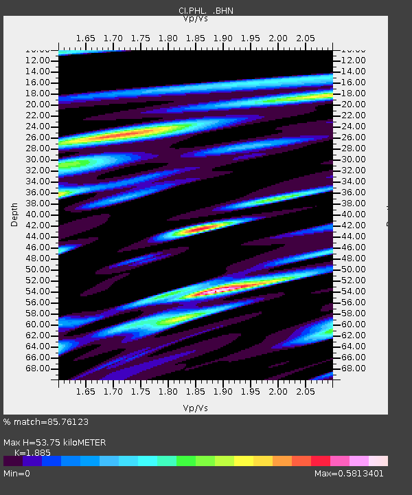
| Estimated Moho Depth: |
53.75 km |
| Estimated Crust Vp/Vs: |
1.88 |
| Assumed Crust Vp: |
6.183 km/s |
| Estimated Crust Vs: |
3.28 km/s |
| Estimated Crust Poisson's Ratio: |
0.30 |
|
| Radial Match: |
85.76123 % |
| Radial Bump: |
400 |
| Transverse Match: |
71.93641 % |
| Transverse Bump: |
400 |
| SOD ConfigId: |
3787 |
| Insert Time: |
2010-02-26 02:11:56.637 +0000 |
| GWidth: |
2.5 |
| Max Bumps: |
400 |
| Tol: |
0.001 |
|
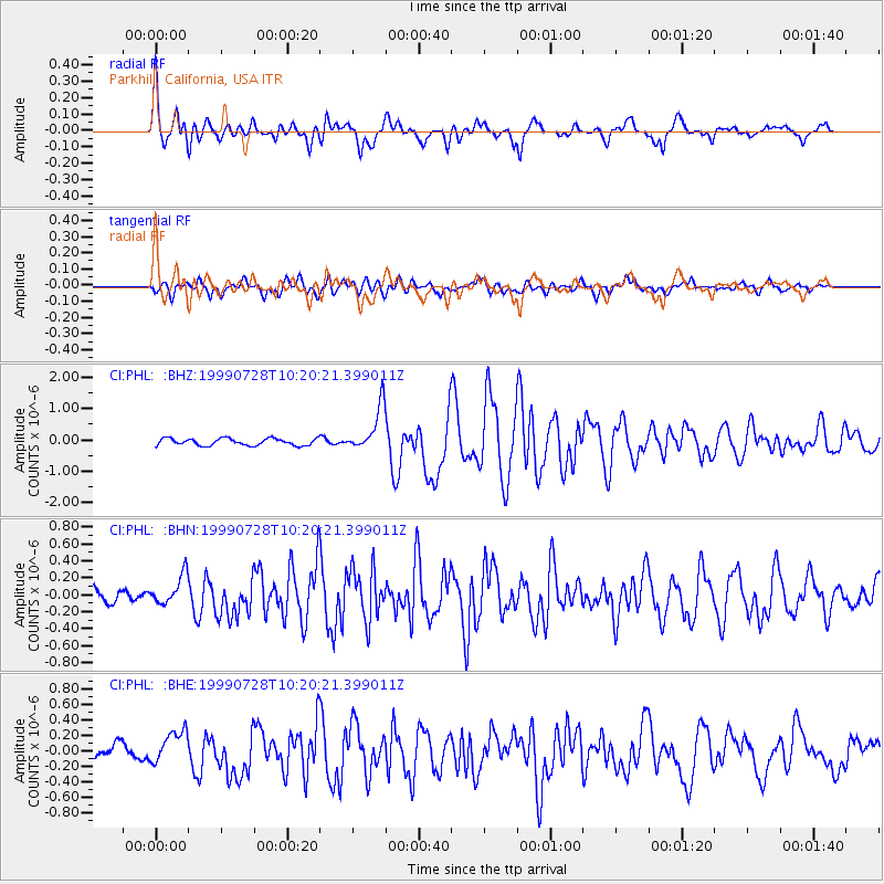
Signal To Noise
| Channel | StoN | STA | LTA |
| CI:PHL: :BHN:19990728T10:20:21.399011Z | 2.3304644 | 1.7437978E-7 | 7.48262E-8 |
| CI:PHL: :BHE:19990728T10:20:21.399011Z | 1.394052 | 2.1883122E-7 | 1.5697492E-7 |
| CI:PHL: :BHZ:19990728T10:20:21.399011Z | 6.4432955 | 7.196304E-7 | 1.1168671E-7 |
| Arrivals |
| Ps | 7.9 SECOND |
| PpPs | 25 SECOND |
| PsPs/PpSs | 32 SECOND |


