You are here: Home > Network List > TA - USArray Transportable Network (new EarthScope stations) Stations List
> Station U21A Nageezi, NM, USA > Earthquake Result Viewer
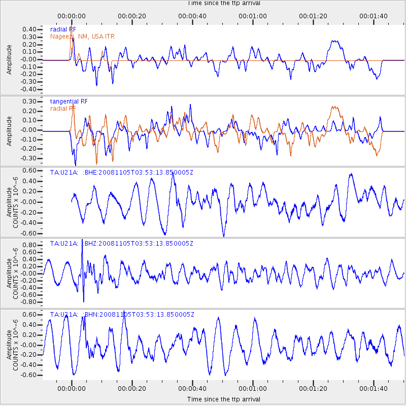
U21A Nageezi, NM, USA - Earthquake Result Viewer
*The percent match for this event was below the threshold and hence no stack was calculated.
| Earthquake location: |
Tonga Islands |
| Earthquake latitude/longitude: |
-17.3/-174.4 |
| Earthquake time(UTC): |
2008/11/05 (310) 03:41:43 GMT |
| Earthquake Depth: |
188 km |
| Earthquake Magnitude: |
5.7 MW, 5.1 MB, 5.7 MW |
| Earthquake Catalog/Contributor: |
WHDF/NEIC |
|
| Network: |
TA USArray Transportable Network (new EarthScope stations) |
| Station: |
U21A Nageezi, NM, USA |
| Lat/Lon: |
36.43 N/107.66 W |
| Elevation: |
2124 m |
|
| Distance: |
82.5 deg |
| Az: |
48.337 deg |
| Baz: |
242.229 deg |
| Ray Param: |
$rayparam |
*The percent match for this event was below the threshold and hence was not used in the summary stack. |
|
| Radial Match: |
62.00678 % |
| Radial Bump: |
400 |
| Transverse Match: |
50.076675 % |
| Transverse Bump: |
400 |
| SOD ConfigId: |
2658 |
| Insert Time: |
2010-03-06 13:55:02.681 +0000 |
| GWidth: |
2.5 |
| Max Bumps: |
400 |
| Tol: |
0.001 |
|
Signal To Noise
| Channel | StoN | STA | LTA |
| TA:U21A: :BHZ:20081105T03:53:13.850005Z | 1.3094988 | 3.3644193E-7 | 2.569242E-7 |
| TA:U21A: :BHN:20081105T03:53:13.850005Z | 1.6384606 | 3.9799593E-7 | 2.4290844E-7 |
| TA:U21A: :BHE:20081105T03:53:13.850005Z | 2.0320122 | 4.1141868E-7 | 2.0246861E-7 |
| Arrivals |
| Ps | |
| PpPs | |
| PsPs/PpSs | |


