You are here: Home > Network List > TA - USArray Transportable Network (new EarthScope stations) Stations List
> Station U21A Nageezi, NM, USA > Earthquake Result Viewer
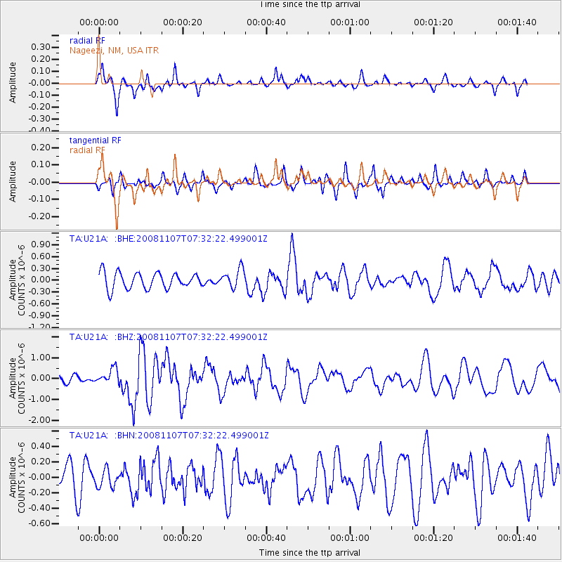
U21A Nageezi, NM, USA - Earthquake Result Viewer
*The percent match for this event was below the threshold and hence no stack was calculated.
| Earthquake location: |
Vanuatu Islands |
| Earthquake latitude/longitude: |
-14.8/168.0 |
| Earthquake time(UTC): |
2008/11/07 (312) 07:19:35 GMT |
| Earthquake Depth: |
13 km |
| Earthquake Magnitude: |
6.0 MB, 6.3 MS, 6.4 MW, 6.4 MW |
| Earthquake Catalog/Contributor: |
WHDF/NEIC |
|
| Network: |
TA USArray Transportable Network (new EarthScope stations) |
| Station: |
U21A Nageezi, NM, USA |
| Lat/Lon: |
36.43 N/107.66 W |
| Elevation: |
2124 m |
|
| Distance: |
94.2 deg |
| Az: |
53.58 deg |
| Baz: |
254.781 deg |
| Ray Param: |
$rayparam |
*The percent match for this event was below the threshold and hence was not used in the summary stack. |
|
| Radial Match: |
79.23934 % |
| Radial Bump: |
400 |
| Transverse Match: |
58.105423 % |
| Transverse Bump: |
317 |
| SOD ConfigId: |
2658 |
| Insert Time: |
2010-03-06 13:55:09.933 +0000 |
| GWidth: |
2.5 |
| Max Bumps: |
400 |
| Tol: |
0.001 |
|
Signal To Noise
| Channel | StoN | STA | LTA |
| TA:U21A: :BHZ:20081107T07:32:22.499001Z | 2.11721 | 3.6367442E-7 | 1.7177061E-7 |
| TA:U21A: :BHN:20081107T07:32:22.499001Z | 0.7079229 | 1.1513088E-7 | 1.6263195E-7 |
| TA:U21A: :BHE:20081107T07:32:22.499001Z | 1.183323 | 2.39465E-7 | 2.0236656E-7 |
| Arrivals |
| Ps | |
| PpPs | |
| PsPs/PpSs | |


