You are here: Home > Network List > TJ - Tajikistan National Seismic Network Stations List
> Station GARM Garm, Tajikistan > Earthquake Result Viewer
GARM Garm, Tajikistan - Earthquake Result Viewer
| Earthquake location: |
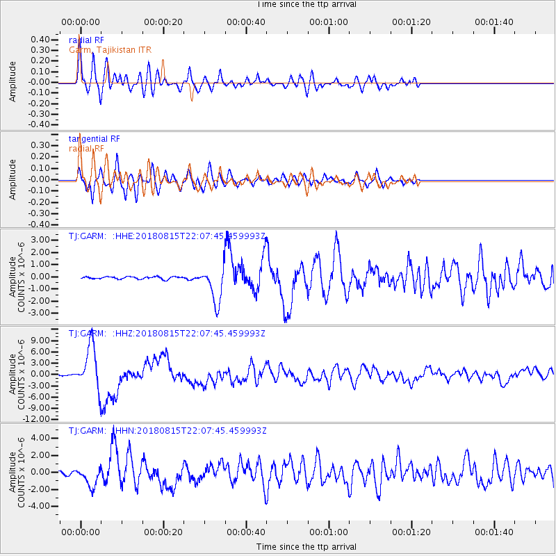
Andreanof Islands, Aleutian Is. |
| Earthquake latitude/longitude: |
51.4/-178.1 |
| Earthquake time(UTC): |
2018/08/15 (227) 21:56:54 GMT |
| Earthquake Depth: |
20 km |
| Earthquake Magnitude: |
6.6 Mww |
| Earthquake Catalog/Contributor: |
NEIC PDE/us |
|
| Network: |
TJ Tajikistan National Seismic Network |
| Station: |
GARM Garm, Tajikistan |
| Lat/Lon: |
39.00 N/70.32 E |
| Elevation: |
1305 m |
|
| Distance: |
72.0 deg |
| Az: |
310.394 deg |
| Baz: |
37.722 deg |
| Ray Param: |
0.05393195 |
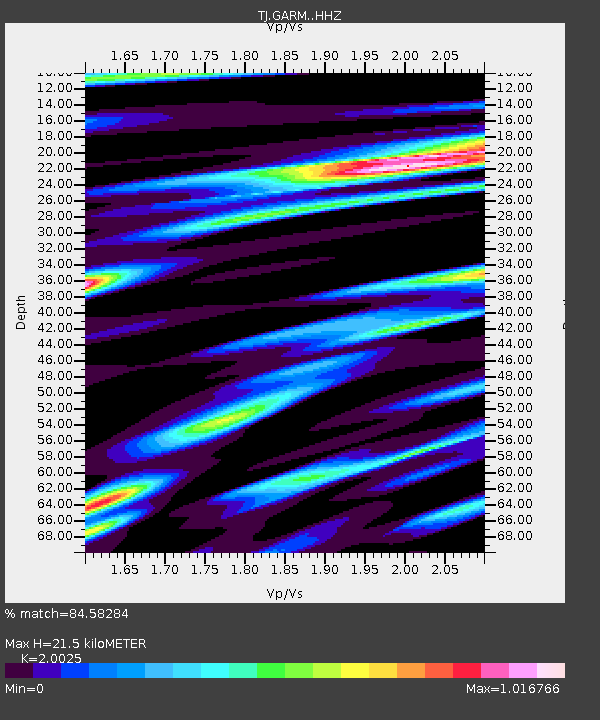
| Estimated Moho Depth: |
21.5 km |
| Estimated Crust Vp/Vs: |
2.00 |
| Assumed Crust Vp: |
6.306 km/s |
| Estimated Crust Vs: |
3.149 km/s |
| Estimated Crust Poisson's Ratio: |
0.33 |
|
| Radial Match: |
84.58284 % |
| Radial Bump: |
400 |
| Transverse Match: |
83.60858 % |
| Transverse Bump: |
400 |
| SOD ConfigId: |
13570011 |
| Insert Time: |
2019-04-30 19:39:46.791 +0000 |
| GWidth: |
2.5 |
| Max Bumps: |
400 |
| Tol: |
0.001 |
|
Signal To Noise
| Channel | StoN | STA | LTA |
| TJ:GARM: :HHZ:20180815T22:07:45.459993Z | 67.15464 | 6.1733954E-6 | 9.192806E-8 |
| TJ:GARM: :HHN:20180815T22:07:45.459993Z | 8.049376 | 1.1723853E-6 | 1.4564922E-7 |
| TJ:GARM: :HHE:20180815T22:07:45.459993Z | 18.229612 | 1.7435109E-6 | 9.564168E-8 |
| Arrivals |
| Ps | 3.5 SECOND |
| PpPs | 9.9 SECOND |
| PsPs/PpSs | 13 SECOND |


