You are here: Home > Network List > UW - Pacific Northwest Regional Seismic Network Stations List
> Station LON Longmire CREST broad-band > Earthquake Result Viewer
LON Longmire CREST broad-band - Earthquake Result Viewer

| Earthquake location: |
Andreanof Islands, Aleutian Is. |
| Earthquake latitude/longitude: |
51.4/-178.1 |
| Earthquake time(UTC): |
2018/08/15 (227) 21:56:54 GMT |
| Earthquake Depth: |
20 km |
| Earthquake Magnitude: |
6.6 Mww |
| Earthquake Catalog/Contributor: |
NEIC PDE/us |
|
| Network: |
UW Pacific Northwest Regional Seismic Network |
| Station: |
LON Longmire CREST broad-band |
| Lat/Lon: |
46.75 N/121.81 W |
| Elevation: |
853 m |
|
| Distance: |
36.4 deg |
| Az: |
74.687 deg |
| Baz: |
298.596 deg |
| Ray Param: |
0.076703265 |
| Estimated Moho Depth: |
42.5 km |
| Estimated Crust Vp/Vs: |
1.60 |
| Assumed Crust Vp: |
6.597 km/s |
| Estimated Crust Vs: |
4.123 km/s |
| Estimated Crust Poisson's Ratio: |
0.18 |
|
| Radial Match: |
93.65182 % |
| Radial Bump: |
389 |
| Transverse Match: |
85.73278 % |
| Transverse Bump: |
400 |
| SOD ConfigId: |
13570011 |
| Insert Time: |
2019-04-30 19:41:12.662 +0000 |
| GWidth: |
2.5 |
| Max Bumps: |
400 |
| Tol: |
0.001 |
|
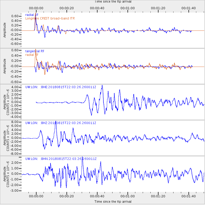
Signal To Noise
| Channel | StoN | STA | LTA |
| UW:LON: :BHZ:20180815T22:03:26.260011Z | 19.635593 | 1.966413E-6 | 1.00145336E-7 |
| UW:LON: :BHN:20180815T22:03:26.260011Z | 6.0744467 | 5.0113675E-7 | 8.249916E-8 |
| UW:LON: :BHE:20180815T22:03:26.260011Z | 11.952645 | 1.0256865E-6 | 8.5812516E-8 |
| Arrivals |
| Ps | 4.2 SECOND |
| PpPs | 15 SECOND |
| PsPs/PpSs | 20 SECOND |


