You are here: Home > Network List > UW - Pacific Northwest Regional Seismic Network Stations List
> Station RATT Rattlesnake Lake, WA > Earthquake Result Viewer
RATT Rattlesnake Lake, WA - Earthquake Result Viewer
| Earthquake location: |
Andreanof Islands, Aleutian Is. |
| Earthquake latitude/longitude: |
51.4/-178.1 |
| Earthquake time(UTC): |
2018/08/15 (227) 21:56:54 GMT |
| Earthquake Depth: |
20 km |
| Earthquake Magnitude: |
6.6 Mww |
| Earthquake Catalog/Contributor: |
NEIC PDE/us |
|
| Network: |
UW Pacific Northwest Regional Seismic Network |
| Station: |
RATT Rattlesnake Lake, WA |
| Lat/Lon: |
47.43 N/121.80 W |
| Elevation: |
440 m |
|
| Distance: |
36.0 deg |
| Az: |
73.676 deg |
| Baz: |
297.784 deg |
| Ray Param: |
0.07687464 |
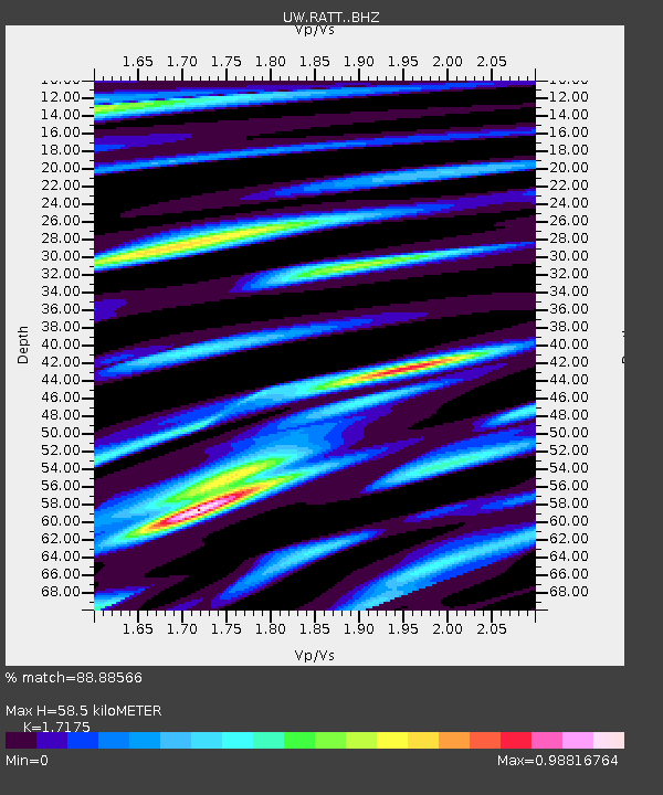
| Estimated Moho Depth: |
58.5 km |
| Estimated Crust Vp/Vs: |
1.72 |
| Assumed Crust Vp: |
6.597 km/s |
| Estimated Crust Vs: |
3.841 km/s |
| Estimated Crust Poisson's Ratio: |
0.24 |
|
| Radial Match: |
88.88566 % |
| Radial Bump: |
400 |
| Transverse Match: |
84.44963 % |
| Transverse Bump: |
400 |
| SOD ConfigId: |
13570011 |
| Insert Time: |
2019-04-30 19:41:21.752 +0000 |
| GWidth: |
2.5 |
| Max Bumps: |
400 |
| Tol: |
0.001 |
|

Signal To Noise
| Channel | StoN | STA | LTA |
| UW:RATT: :BHZ:20180815T22:03:23.565004Z | 17.65249 | 2.434537E-6 | 1.3791464E-7 |
| UW:RATT: :BHN:20180815T22:03:23.565004Z | 2.0929403 | 2.666417E-7 | 1.2740053E-7 |
| UW:RATT: :BHE:20180815T22:03:23.565004Z | 7.9057026 | 1.3251195E-6 | 1.6761565E-7 |
| Arrivals |
| Ps | 6.9 SECOND |
| PpPs | 22 SECOND |
| PsPs/PpSs | 29 SECOND |


