You are here: Home > Network List > TA - USArray Transportable Network (new EarthScope stations) Stations List
> Station S24A Houchin Ranch, La Veta, CO, USA > Earthquake Result Viewer
S24A Houchin Ranch, La Veta, CO, USA - Earthquake Result Viewer
| Earthquake location: |
Rat Islands, Aleutian Islands |
| Earthquake latitude/longitude: |
51.3/179.0 |
| Earthquake time(UTC): |
2008/07/25 (207) 00:29:22 GMT |
| Earthquake Depth: |
21 km |
| Earthquake Magnitude: |
5.7 MB, 5.5 MS, 5.9 MW, 5.9 MW |
| Earthquake Catalog/Contributor: |
WHDF/NEIC |
|
| Network: |
TA USArray Transportable Network (new EarthScope stations) |
| Station: |
S24A Houchin Ranch, La Veta, CO, USA |
| Lat/Lon: |
37.64 N/105.21 W |
| Elevation: |
2672 m |
|
| Distance: |
53.5 deg |
| Az: |
73.328 deg |
| Baz: |
310.717 deg |
| Ray Param: |
0.06606185 |
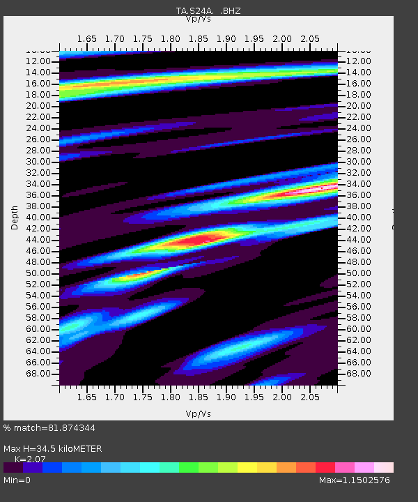
| Estimated Moho Depth: |
34.5 km |
| Estimated Crust Vp/Vs: |
2.07 |
| Assumed Crust Vp: |
6.316 km/s |
| Estimated Crust Vs: |
3.051 km/s |
| Estimated Crust Poisson's Ratio: |
0.35 |
|
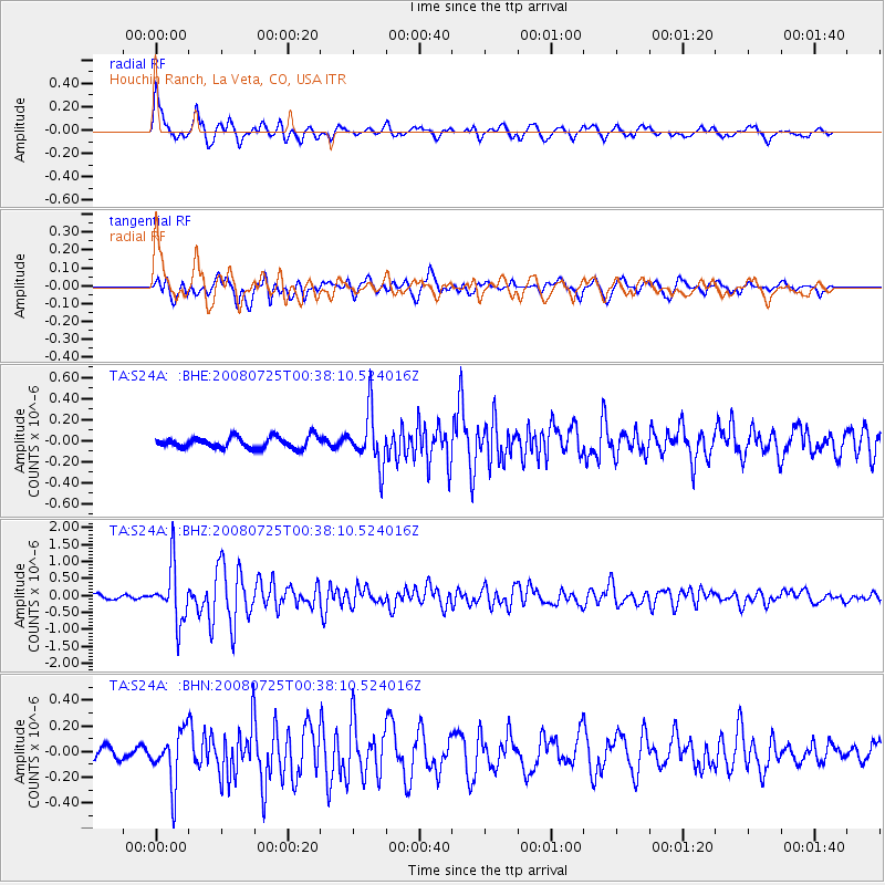
| Radial Match: |
81.874344 % |
| Radial Bump: |
400 |
| Transverse Match: |
69.661194 % |
| Transverse Bump: |
400 |
| SOD ConfigId: |
2504 |
| Insert Time: |
2010-03-06 13:55:38.049 +0000 |
| GWidth: |
2.5 |
| Max Bumps: |
400 |
| Tol: |
0.001 |
|
Signal To Noise
| Channel | StoN | STA | LTA |
| TA:S24A: :BHZ:20080725T00:38:10.524016Z | 11.631993 | 8.1138506E-7 | 6.9754606E-8 |
| TA:S24A: :BHN:20080725T00:38:10.524016Z | 4.202426 | 2.1117788E-7 | 5.0251423E-8 |
| TA:S24A: :BHE:20080725T00:38:10.524016Z | 4.6582727 | 2.517348E-7 | 5.4040378E-8 |
| Arrivals |
| Ps | 6.1 SECOND |
| PpPs | 16 SECOND |
| PsPs/PpSs | 22 SECOND |


