You are here: Home > Network List > TA - USArray Transportable Network (new EarthScope stations) Stations List
> Station S24A Houchin Ranch, La Veta, CO, USA > Earthquake Result Viewer
S24A Houchin Ranch, La Veta, CO, USA - Earthquake Result Viewer
| Earthquake location: |
Central East Pacific Rise |
| Earthquake latitude/longitude: |
-4.6/-106.0 |
| Earthquake time(UTC): |
2008/09/18 (262) 01:41:02 GMT |
| Earthquake Depth: |
10 km |
| Earthquake Magnitude: |
5.5 MB, 5.7 MS, 6.0 MW, 6.0 MW |
| Earthquake Catalog/Contributor: |
WHDF/NEIC |
|
| Network: |
TA USArray Transportable Network (new EarthScope stations) |
| Station: |
S24A Houchin Ranch, La Veta, CO, USA |
| Lat/Lon: |
37.64 N/105.21 W |
| Elevation: |
2672 m |
|
| Distance: |
42.0 deg |
| Az: |
0.934 deg |
| Baz: |
181.173 deg |
| Ray Param: |
0.07344348 |
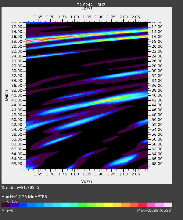
| Estimated Moho Depth: |
17.75 km |
| Estimated Crust Vp/Vs: |
1.60 |
| Assumed Crust Vp: |
6.316 km/s |
| Estimated Crust Vs: |
3.947 km/s |
| Estimated Crust Poisson's Ratio: |
0.18 |
|
| Radial Match: |
81.76345 % |
| Radial Bump: |
400 |
| Transverse Match: |
66.62215 % |
| Transverse Bump: |
400 |
| SOD ConfigId: |
2560 |
| Insert Time: |
2010-03-06 13:56:03.328 +0000 |
| GWidth: |
2.5 |
| Max Bumps: |
400 |
| Tol: |
0.001 |
|
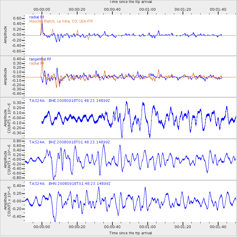
Signal To Noise
| Channel | StoN | STA | LTA |
| TA:S24A: :BHZ:20080918T01:48:23.14899Z | 2.3598459 | 2.2023212E-7 | 9.332479E-8 |
| TA:S24A: :BHN:20080918T01:48:23.14899Z | 1.7794873 | 1.200476E-7 | 6.7461905E-8 |
| TA:S24A: :BHE:20080918T01:48:23.14899Z | 0.91990745 | 5.427698E-8 | 5.9002655E-8 |
| Arrivals |
| Ps | 1.8 SECOND |
| PpPs | 6.8 SECOND |
| PsPs/PpSs | 8.6 SECOND |


