You are here: Home > Network List > TA - USArray Transportable Network (new EarthScope stations) Stations List
> Station S24A Houchin Ranch, La Veta, CO, USA > Earthquake Result Viewer
S24A Houchin Ranch, La Veta, CO, USA - Earthquake Result Viewer
| Earthquake location: |
Off Coast Of Costa Rica |
| Earthquake latitude/longitude: |
7.9/-85.6 |
| Earthquake time(UTC): |
2009/08/13 (225) 09:37:35 GMT |
| Earthquake Depth: |
10 km |
| Earthquake Magnitude: |
5.8 MW, 5.3 MB |
| Earthquake Catalog/Contributor: |
WHDF/NEIC |
|
| Network: |
TA USArray Transportable Network (new EarthScope stations) |
| Station: |
S24A Houchin Ranch, La Veta, CO, USA |
| Lat/Lon: |
37.64 N/105.21 W |
| Elevation: |
2672 m |
|
| Distance: |
34.5 deg |
| Az: |
331.967 deg |
| Baz: |
144.096 deg |
| Ray Param: |
0.07772285 |
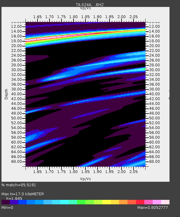
| Estimated Moho Depth: |
17.0 km |
| Estimated Crust Vp/Vs: |
1.64 |
| Assumed Crust Vp: |
6.316 km/s |
| Estimated Crust Vs: |
3.839 km/s |
| Estimated Crust Poisson's Ratio: |
0.21 |
|
| Radial Match: |
85.5191 % |
| Radial Bump: |
400 |
| Transverse Match: |
64.008415 % |
| Transverse Bump: |
400 |
| SOD ConfigId: |
2622 |
| Insert Time: |
2010-03-06 13:56:23.777 +0000 |
| GWidth: |
2.5 |
| Max Bumps: |
400 |
| Tol: |
0.001 |
|
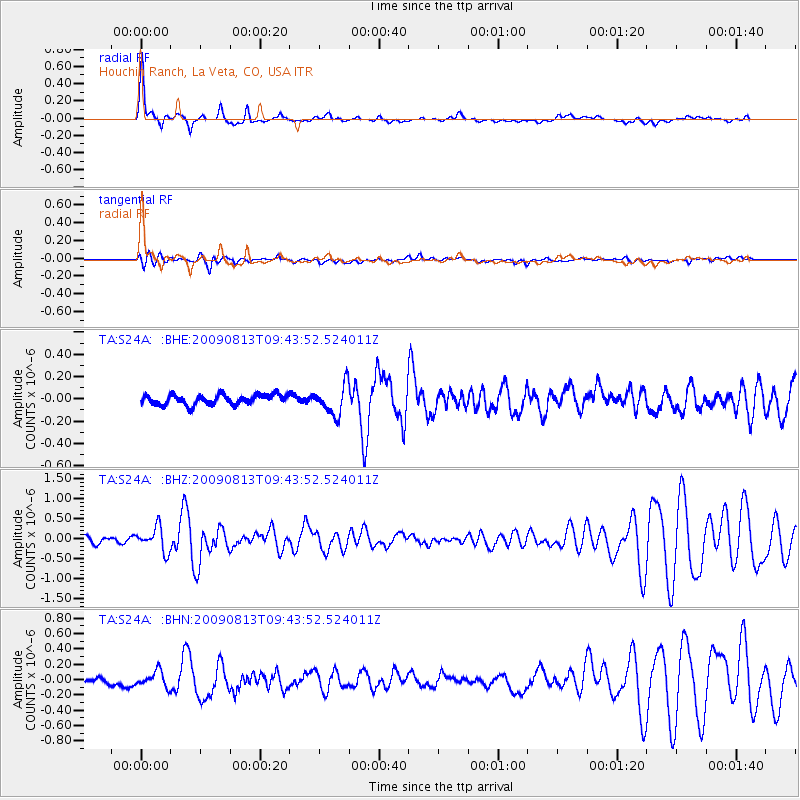
Signal To Noise
| Channel | StoN | STA | LTA |
| TA:S24A: :BHZ:20090813T09:43:52.524011Z | 3.5039654 | 3.0086943E-7 | 8.5865416E-8 |
| TA:S24A: :BHN:20090813T09:43:52.524011Z | 2.4992929 | 1.01168276E-7 | 4.047876E-8 |
| TA:S24A: :BHE:20090813T09:43:52.524011Z | 2.9414916 | 1.3403887E-7 | 4.556833E-8 |
| Arrivals |
| Ps | 1.9 SECOND |
| PpPs | 6.6 SECOND |
| PsPs/PpSs | 8.5 SECOND |


