You are here: Home > Network List > IU - Global Seismograph Network (GSN - IRIS/USGS) Stations List
> Station PMG Port Moresby, New Guinea > Earthquake Result Viewer
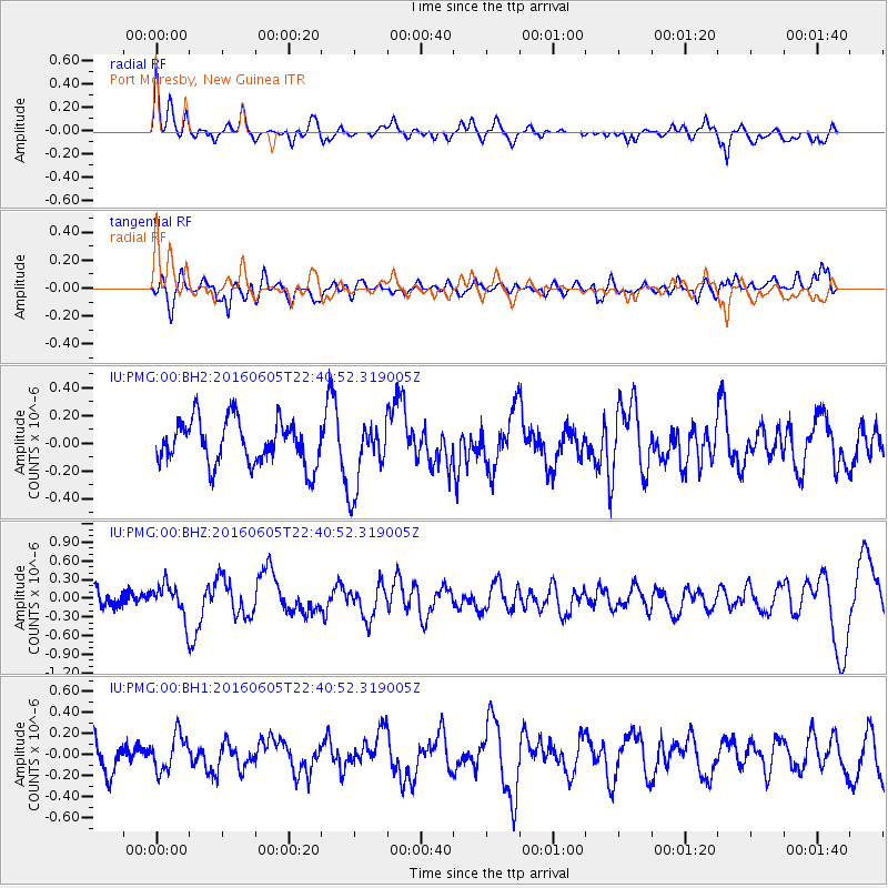
PMG Port Moresby, New Guinea - Earthquake Result Viewer
*The percent match for this event was below the threshold and hence no stack was calculated.
| Earthquake location: |
Tonga Islands Region |
| Earthquake latitude/longitude: |
-17.6/-172.6 |
| Earthquake time(UTC): |
2016/06/05 (157) 22:33:49 GMT |
| Earthquake Depth: |
10 km |
| Earthquake Magnitude: |
5.6 MWW, 5.6 MWC, 5.6 MWB |
| Earthquake Catalog/Contributor: |
NEIC PDE/NEIC COMCAT |
|
| Network: |
IU Global Seismograph Network (GSN - IRIS/USGS) |
| Station: |
PMG Port Moresby, New Guinea |
| Lat/Lon: |
9.40 S/147.16 E |
| Elevation: |
90 m |
|
| Distance: |
39.9 deg |
| Az: |
276.472 deg |
| Baz: |
106.222 deg |
| Ray Param: |
$rayparam |
*The percent match for this event was below the threshold and hence was not used in the summary stack. |
|
| Radial Match: |
68.73471 % |
| Radial Bump: |
400 |
| Transverse Match: |
46.96377 % |
| Transverse Bump: |
400 |
| SOD ConfigId: |
1634031 |
| Insert Time: |
2016-07-02 18:53:16.833 +0000 |
| GWidth: |
2.5 |
| Max Bumps: |
400 |
| Tol: |
0.001 |
|
Signal To Noise
| Channel | StoN | STA | LTA |
| IU:PMG:00:BHZ:20160605T22:40:52.319005Z | 2.0325162 | 2.8157208E-7 | 1.3853375E-7 |
| IU:PMG:00:BH1:20160605T22:40:52.319005Z | 1.2069006 | 1.7219371E-7 | 1.4267431E-7 |
| IU:PMG:00:BH2:20160605T22:40:52.319005Z | 1.5729629 | 2.491598E-7 | 1.5840158E-7 |
| Arrivals |
| Ps | |
| PpPs | |
| PsPs/PpSs | |


