You are here: Home > Network List > KZ - Kazakhstan Network Stations List
> Station PDGK Podgonoye, Kazakstan > Earthquake Result Viewer
PDGK Podgonoye, Kazakstan - Earthquake Result Viewer
| Earthquake location: |
Volcano Islands, Japan Region |
| Earthquake latitude/longitude: |
23.4/143.4 |
| Earthquake time(UTC): |
2018/08/16 (228) 18:21:31 GMT |
| Earthquake Depth: |
12 km |
| Earthquake Magnitude: |
5.8 Mwb |
| Earthquake Catalog/Contributor: |
NEIC PDE/us |
|
| Network: |
KZ Kazakhstan Network |
| Station: |
PDGK Podgonoye, Kazakstan |
| Lat/Lon: |
43.33 N/79.48 E |
| Elevation: |
1290 m |
|
| Distance: |
55.6 deg |
| Az: |
307.44 deg |
| Baz: |
89.236 deg |
| Ray Param: |
0.0646806 |
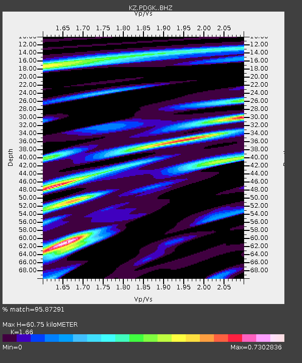
| Estimated Moho Depth: |
60.75 km |
| Estimated Crust Vp/Vs: |
1.66 |
| Assumed Crust Vp: |
6.306 km/s |
| Estimated Crust Vs: |
3.799 km/s |
| Estimated Crust Poisson's Ratio: |
0.22 |
|
| Radial Match: |
95.87291 % |
| Radial Bump: |
400 |
| Transverse Match: |
92.12969 % |
| Transverse Bump: |
400 |
| SOD ConfigId: |
13570011 |
| Insert Time: |
2019-04-30 19:46:14.263 +0000 |
| GWidth: |
2.5 |
| Max Bumps: |
400 |
| Tol: |
0.001 |
|

Signal To Noise
| Channel | StoN | STA | LTA |
| KZ:PDGK: :BHZ:20180816T18:30:35.751023Z | 13.407303 | 7.015776E-7 | 5.2328023E-8 |
| KZ:PDGK: :BHN:20180816T18:30:35.751023Z | 2.9151413 | 1.2336936E-7 | 4.23202E-8 |
| KZ:PDGK: :BHE:20180816T18:30:35.751023Z | 6.065833 | 2.9360407E-7 | 4.8402928E-8 |
| Arrivals |
| Ps | 6.7 SECOND |
| PpPs | 24 SECOND |
| PsPs/PpSs | 31 SECOND |


