You are here: Home > Network List > TA - USArray Transportable Network (new EarthScope stations) Stations List
> Station S24A Houchin Ranch, La Veta, CO, USA > Earthquake Result Viewer
S24A Houchin Ranch, La Veta, CO, USA - Earthquake Result Viewer

| Earthquake location: |
Northern Mid-Atlantic Ridge |
| Earthquake latitude/longitude: |
23.9/-46.1 |
| Earthquake time(UTC): |
2009/06/06 (157) 20:33:28 GMT |
| Earthquake Depth: |
14 km |
| Earthquake Magnitude: |
6.0 MB, 5.7 MS, 6.0 MW, 6.0 MW |
| Earthquake Catalog/Contributor: |
WHDF/NEIC |
|
| Network: |
TA USArray Transportable Network (new EarthScope stations) |
| Station: |
S24A Houchin Ranch, La Veta, CO, USA |
| Lat/Lon: |
37.64 N/105.21 W |
| Elevation: |
2672 m |
|
| Distance: |
51.8 deg |
| Az: |
299.968 deg |
| Baz: |
87.558 deg |
| Ray Param: |
0.06713581 |
| Estimated Moho Depth: |
14.5 km |
| Estimated Crust Vp/Vs: |
1.87 |
| Assumed Crust Vp: |
6.316 km/s |
| Estimated Crust Vs: |
3.373 km/s |
| Estimated Crust Poisson's Ratio: |
0.30 |
|
| Radial Match: |
86.802414 % |
| Radial Bump: |
400 |
| Transverse Match: |
75.73899 % |
| Transverse Bump: |
400 |
| SOD ConfigId: |
2648 |
| Insert Time: |
2010-03-06 13:56:59.913 +0000 |
| GWidth: |
2.5 |
| Max Bumps: |
400 |
| Tol: |
0.001 |
|
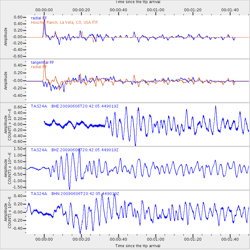
Signal To Noise
| Channel | StoN | STA | LTA |
| TA:S24A: :BHZ:20090606T20:42:05.449019Z | 3.1987467 | 2.2434754E-7 | 7.013608E-8 |
| TA:S24A: :BHN:20090606T20:42:05.449019Z | 1.1377009 | 8.224393E-8 | 7.228958E-8 |
| TA:S24A: :BHE:20090606T20:42:05.449019Z | 1.4930102 | 1.0071215E-7 | 6.745577E-8 |
| Arrivals |
| Ps | 2.1 SECOND |
| PpPs | 6.3 SECOND |
| PsPs/PpSs | 8.4 SECOND |


